Remaining lock-ups are a bit thin on the ground in this part of the world.
The lock-up at Alcester in Warwickshire is situated on the ground floor of the old Town Hall in Church Street, B49 5QX and probably dates to the 18th century when the open arcades were filled in to form a lock-up in the south west bay. The building actually dates to c1618.
 |
ALCESTER OS Grid Reference: SP0908257521 OS Grid Coordinates: 409082, 257521 Latitude/Longitude: 52.2158, -1.8685 Photo by Stephen McKay © Copyright Stephen McKay and licensed for reuse under this Creative Commons Licence
I am grateful to Stephen McKay for the use of his photograph on Geograph.
It was Grade 11 listed 10.2.1956 (No.395224) and described as : Town Hall, c.1618. Ground floor.................former lock-up in south-west bay. Listing NGR: SP0908257521
Source: English Heritage
Listed building text is © Crown Copyright. Reproduced under licence.
ooooooooooooooooooooooooooooooooooooooooooooooooooooooo There are three individual lock-up cells at Bewdley in Worcestershire situated in their original position in Load Street, DY12 2AS, behind the Town Hall and Shambles, now Bewdley Museum and they date to 1783 with some 20th century restoration. The original doors, which were replaced, are stored at the museum.  |
BEWDLEY
OS Grid Reference: SO7867875294
OS Grid Coordinates: 378678, 275294
Latitude/Longitude: 52.3753, -2.3146
Photo courtsesy of Bewdley Museum
Together with The Shambles, they were Grade 11 listed 2.10.1975 (No.156796) and described as :
Market building and prison cells, now part of Bewdley Museum. 1783 with
some late C20 restoration. Brick with tile roofs. Two parallel ranges
running back (south-east) from Town Hall (qv) with 14 bays to the north
range, 15 to the south. Bays open to front with segmental arches on square
brick piers, south-east closed by a single arch with blank wall at back.
Attached at south corner are three prison cells; two facing north-west have
rusticated ashlar surrounds, fanlights with wrought iron infill and studded
boarded doors with strap hinges. (Hereford and Worcester Record Office, BA
2432, box 3, no 49b).
Listing NGR: SO7867875294
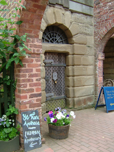
Photo courtesy of Bewdley Museum
This cell has a datestone for 1802.
"The interior of the lock-up was sparse consisting of a stone bed with a wooden board and a small grate. Once the door was locked the cell would have been dark, poorly ventilated and the grate would have provided only a little warmth if the prisoner had been fortunate enough to persuade someone to light a fire."

Photo courtesy of Bewdley Museum
Bewdley's pillory and stocks were also in Load Street.
"It was said that Bewdley had a high proportion of criminals, possibly due to the town having ' a smaller proportion of schools and a larger proportion of public houses than any other town in the country.' At its height Bewdley had as many as thirty public houses."
"As early as 1447 there was a lock-up in the gatehouse on the bridge, which was severely damaged by floods in 1795 and the lock-up was not replaced when a new bridge was built.
In any case in 1627 the 'New House' with a 'strong cage' was built under the old Town Hall and it was demolished in 1793. This probably coincided with the Charter by James 1 of 1605 which allowed towns to police themselves with a Constable and J.P to deal with minor offences. More serious offences were dealt with at Quarter Sessions or Assizes".
http://www.wyreforestdc.gov.uk/cms/leisure-and-culture/museums-and-galleries.aspx
I am most grateful to Liz Cowley of Bewdley Museum for sending me these photographs and an information leaflet about the lock-up.
oooooooooooooooooooooooooooooooooooooooooooooooooooooooooooooooooooooooo
OS Grid Reference: SO7867875294
OS Grid Coordinates: 378678, 275294
Latitude/Longitude: 52.3753, -2.3146
Photo courtsesy of Bewdley Museum
Together with The Shambles, they were Grade 11 listed 2.10.1975 (No.156796) and described as :
Market building and prison cells, now part of Bewdley Museum. 1783 with
some late C20 restoration. Brick with tile roofs. Two parallel ranges
running back (south-east) from Town Hall (qv) with 14 bays to the north
range, 15 to the south. Bays open to front with segmental arches on square
brick piers, south-east closed by a single arch with blank wall at back.
Attached at south corner are three prison cells; two facing north-west have
rusticated ashlar surrounds, fanlights with wrought iron infill and studded
boarded doors with strap hinges. (Hereford and Worcester Record Office, BA
2432, box 3, no 49b).
Listing NGR: SO7867875294
Source: English Heritage
Listed building text is © Crown Copyright. Reproduced under licence.

Photo courtesy of Bewdley Museum
This cell has a datestone for 1802.
"The interior of the lock-up was sparse consisting of a stone bed with a wooden board and a small grate. Once the door was locked the cell would have been dark, poorly ventilated and the grate would have provided only a little warmth if the prisoner had been fortunate enough to persuade someone to light a fire."

Photo courtesy of Bewdley Museum
Bewdley's pillory and stocks were also in Load Street.
"It was said that Bewdley had a high proportion of criminals, possibly due to the town having ' a smaller proportion of schools and a larger proportion of public houses than any other town in the country.' At its height Bewdley had as many as thirty public houses."
"As early as 1447 there was a lock-up in the gatehouse on the bridge, which was severely damaged by floods in 1795 and the lock-up was not replaced when a new bridge was built.
In any case in 1627 the 'New House' with a 'strong cage' was built under the old Town Hall and it was demolished in 1793. This probably coincided with the Charter by James 1 of 1605 which allowed towns to police themselves with a Constable and J.P to deal with minor offences. More serious offences were dealt with at Quarter Sessions or Assizes".
http://www.wyreforestdc.gov.uk/cms/leisure-and-culture/museums-and-galleries.aspx
I am most grateful to Liz Cowley of Bewdley Museum for sending me these photographs and an information leaflet about the lock-up.
oooooooooooooooooooooooooooooooooooooooooooooooooooooooooooooooooooooooo


