.jpg)
The volcanic island of Mull is renowned for its diversity of landscapes with its highest point of Ben More at 3130 feet.
The car ferry to Mull is just a short distance from Oban to Craignure across the Firth of Lorn passing the southern tip of Lismore Island.

Lismore Isle
At this point the ferry passes Duart Point on the eastern corner of Mull and close to Duart Castle built in c1250, the ancestral home of the Clan McLean chiefs.
It was extensively restored in the early 19th century.
It was extensively restored in the early 19th century.

The capital of Mull is the little fishing harbour town of Tobermory on the north eastern corner of the island. With a population of just 700 it is the only town on the island. Fondly remembered as Balamory in the children's TV series it is notable for its colourful buildings.
.jpg)

The roads on the island are not very good and the road leading west from Tobermory has spectacular twists and turns. There is little or no access to the coast until the area around Dervaig where there is a lovely beach.

.jpg)
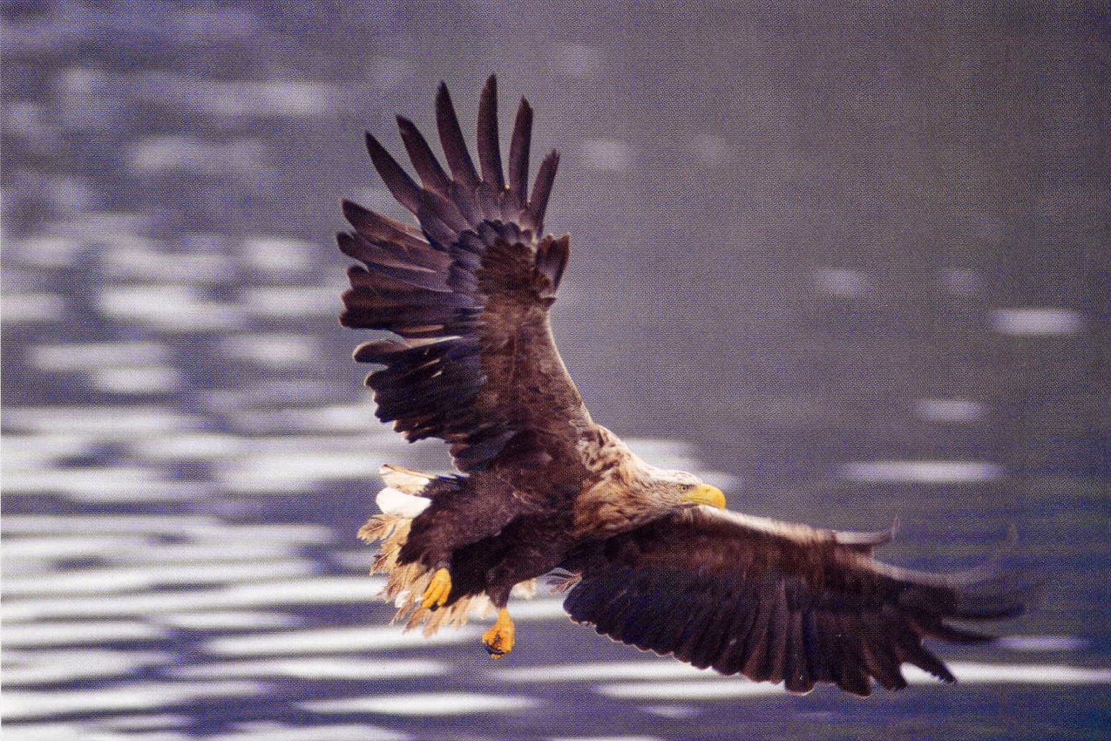
The road along the coast leads through spectacular scenery with views of Ulva and Gometra and alongside Loch Na Keal. This is the area to catch sight of the huge resident sea eagles which nest in the trees overlooking the end of the loch.


.jpg)
.jpg)


The A849 road is a picturesque route to the south west and the Ross of Mull.
The road ends at Fionnphort on the Sound of Iona. Here a road which is no more than a track leads down to a spectacular rocky coast line.


Fionnphort is a tiny hamlet and ferry port giving access to Iona. Apart from a pub and small shop there is just a cluster of houses.


The busy car ferry makes a swift crossing to Iona giving fine views up the coast.

.jpg)
.jpg)


The lovely 8th century Celtic cross of St Martin stands in front of the Cathedral.

Another car ferry crosses the Sound of Mull just north of Craignure to Lochaline in the remote southwest Highland Region of the mainland.
.jpg)
.jpg)
.jpg)
.jpg)
.jpg)

The remote area of the southwest Highland Region has spectacular scenery
of mountains and lochs.

.jpg)
.jpg)
A cairn on the northeast side of Loch nan Uamh reminds us that this is the spot where Bonnie Prince Charlie embarked for France in September 1746 following his defeat at the Battle of Culloden. The Prince had arrived from France
in this area a year earlier.
in this area a year earlier.
The cairn is situated alongside the A830 road from Fort William to Mallaig, popularly known as 'The Road to the Isles'. The road ends at Mallaig where there is a ferry across the Sound of Sleat to Skye.


Prince Charlie raised his standard a few miles away at Glenfinnan
at the head of Loch Shiel on 19th August 1745. With an army of some 1300 men he set out on his epic venture which culminated in his defeat at the Battle of Culloden.


A monument to the Highlanders who followed the Prince in the '45, is topped by a fine statue of a Highlander and was erected in 1815 by Macdonald of Glenaladale, a grandson of one of the Prince's original supporters.
It is now in the care of The National Trust for Scotland.

FORT WILLIAM, capitol of Lochaber District lies at the southern end of the Great Glen overlooking Loch Linnhe at the foot of Ben Nevis, the highest mountain in the UK (4410ft).


More information can be found about the uprising at the
West Highland Museum.
A curious painting can be seen in
this museum.
Known as the ‘secret portrait’,
it is just an apparent mess of paint until it is viewed as a reflection in a glass,
when it becomes a very nice portrait of Bonnie Prince Charlie.

The summit of Ben Nevis is often shrouded in mist and snow often lingers
all year round.

.jpg) |
Glen Nevis is one of the loveliest glens in Scotland.
On the south side of Glen there is
a huge, man high, glacial boulder.
Officially called Samuel’s Stone it appears to commemorate an old battle. A notice alongside tells us that it is a
‘Stone of Council’ and a ‘Wishing Stone’.
Apparently one runs round the stone three times to make a wish.
  The Caledonian Canal was built by Thomas Telford between 1803 and 1822 to link the Atlantic and the North Sea providing a short cut for merchant shipping. Lochs make up a major part of the 60 mile waterway so only 20 miles was canalised.  |
The Commando Memorial at Spean Bridge is dedicated to the men of the original Commando Forces raised during WW2 and overlooks the training areas established in 1942 at nearby Achnacarry Castle.

Further along the Great Glen Loch Lochy joins with Loch Oich which in turn is connected by canal and through a series of locks at Fort Augustus to join Loch Ness and thence into the Beauly Firth at Inverness.
Invergarry is a small village where the River Garry flows into Loch Oich.
On25 September 1662 Alexander Macdonald, the young chief of
Keppoch, and his brother Ranald, were stabbed to death by rivals within their
clan. Nothing was done to avenge their
deaths until Iain Lom, the Keppoch bard, nagged MacDonald of Glengarry and Sir
James McDonald of Sleat to punish the criminals. Two years later the Privy Council in Edinburgh
‘Fire & Sword’ against the murderers.
The seven men were hunted down at Inverlair, killed and decapitated. Legend says that their heads were washed in a well at the side of Loch Oich and taken toInvergarry
Castle Edinburgh 7 December 1665 . A
monument over the well on the west side of Loch Oich at its southern
extremity recalls this event with an inscription in Gaelic,English, French and
Latin. The seven heads are carved around the top of the pillar together with a
hand clasping a dagger.


Invergarry is a small village where the River Garry flows into Loch Oich.
On
‘Fire & Sword’ against the murderers.
The seven men were hunted down at Inverlair, killed and decapitated. Legend says that their heads were washed in a well at the side of Loch Oich and taken to
In 1729, Governor General Wade built a fort at the southern end of Loch Ness and it was named after William Augustus, Duke of Cumberland, the second son of George 11.
Here the canal and six locks connect the waterway to Loch Ness.


This bridge was originally a stone bridge built by soldiers after the Jacobite defeat in 1746. On the main road south it carried not only the military but also thousands of cattle, sheep and ponies on the Drove Route to markets in the south.
In 1849 disaster struck when great floods destroyed two of its three stone arches. Local man Joseph Mitchell, who had trained under Thomas Telford whilst building the Caledonian Canal, obtained permission to repair the bridge and used the centuries old trestle style as a 'temporary' repair which is still in position today and is a listed monument. It was subsequently replaced by the fine stone bridge close by as used today and is no longer in use.
A Preservation Trust is hoping to restore this historic bridge to its former state of 1840

Loch Ness is some 23 miles long and no more than 1 mile wide. It is perhaps the most famous loch because of its association with 'Nessie' the supposed Loch Ness Monster. With a depth of 820 feet Nessie has plenty of hiding places!
.JPG)


Urquart Castle on the northern shore of the loch has foundations which dates to the 13th century but the tower-house and curtain wall date to the 16th century. The castle was destroyed by Government troops in 1692
