Sunday 26 May 2013

DORSET. lock-ups at Cerne Abbas, Corfe Castle, Gillingham, Okeford Fitzpatrick, Poole, Swanage & Lyme Regis.


There was a lock-up at Cerne Abbas but all that remains of it is a flint wall with the outline of a filled in doorway. It is situated in Long Street opposite the Royal Oak Inn.
There is a sketch of the wall in Some West Country Lock-Ups by Leslie Brook, page 35.


ooooooooooooooooooooooooooooooooooooooooooooooooooooooooooooooo


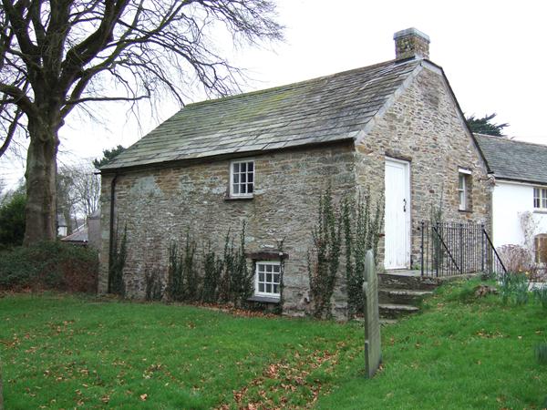
The lock-up at Corfe Castle, also known as The Blind House, is situated on the ground floor (right) of the Old Town Hall, West Street, BH20 5HE and dates to the 17th century.
The upper floor of the building was added in 1774 to house the Council Chamber.


CORFE CASTLE

OS Grid Reference: SY9603282053
OS Grid Coordinates: 396032, 82053
Latitude/Longitude: 50.6382, -2.0575

Photo by Louise Haywood.

 
I am  grateful to Louise Haywood for sending me this photograph and information about the lock-up.
 
 
The building was Grade 11* listed 20.11.1958 (No.109291). The lock-up is built from rubble stone. Now fully renovated and said to be the smallest town hall in England, it is now the village museum.


ooooooooooooooooooooooooooooooooooooooooooooooooooooooooooooooooooooooo


The lock-up at Gillingham is situated at 5 South Street, SP8 4AT and is now
PRIVATE PROPERTY.
It dates to c1750.


 GILLINGHAM

OS Grid Reference: ST8066326510
OS Grid Coordinates: 380663, 126510
Latitude/Longitude: 51.0376, -2.2772
 
Photos by Colin Sinnott
 
 
With many thanks once again to Colin for his supply of photographs.
 
 
It was Grade 11 listed 3.1.1985 (No.102990) and described as :
 
Lock-up, early C19. Coursed, squared rubble with gable-ended, tiled
roof. Single storey. No windows. Central bay projects slightly.
Unmoulded, central doorway with 4-centred head and simple pitched label.
Studded plank door.
(RCHM, Dorset, vol IV, p 30, no 9).
Listing NGR: ST8066326510

Source: English Heritage
Listed building text is © Crown Copyright. Reproduced under licence: PSI Click-use licence number C2008002006.


PLEASE RESPECT PRIVATE PROPERTY.


oooooooooooooooooooooooooooooooooooooooooooooooooooooooooooooooooooooooooo


There was a lock-up at Okeford Fitzpatrick. Attached to a barn the whole site was subsequently converted into a charming thatched cottage.. The oak door with grille and pointed arch doorway were incorporated into the facade of the new building.
 There is a sketch of the building in Lelie Brooke's book page 43.

PLEASE RESPECT PRIVATE PROPERTY


oooooooooooooooooooooooooooooooooooooooooooooooooooooooooooooooo


The lock-up, later a fire engine house, at POOLE is situated in Paradise Street, BH15 1ZA
against the rear of the Town Cellar. It dates to 1820 (datestone) and is now a PRIVATE STORE.


POOLE

OS Grid Reference: SZ0086490320
OS Grid Coordinates: 400864, 90320
Latitude/Longitude: 50.7125, -1.9891

Photo's by Roy Pledger


It was Grade 11 listed 14.6.1954 (No.412573) and described as :


 Gaol, now store. 1820. Limestone ashlar with a slate roof.
Single-room plan. Single storey; 2-window range. 2 small
barred windows and studded door between have chamfered
surrounds; later double door inserted in the W end when used
as fire station. INTERIOR not inspected.
An historically significant survival, built as a lean-to
against The Town Cellar (qv).
(RCHME: County of Dorset (South East): London: 1970-: 204).
Listing NGR: SZ0086490320

Source: English Heritage
Listed building text is © Crown Copyright. Reproduced under licence: PSI Click-use licence number C2008002006.


Possibly the original door.
 
 
PLEASE RESPECT PRIVATE PROPERTY.


oooooooooooooooooooooooooooooooooooooooooooooooo


This lock-up at Swanage dates to 1803 (datestone). It was moved from a corner of the churchyard in about 1860 to its present location in  a small square behind the town  hall.
It does not appear to be a listed building.


SWANAGE

Photo by John Allen.

I am grateful to John Allen for giving me permission to copy this photograph.


The plaque over the door reads :
 
' Erected
for the Prevention
of
Vice & Immorality
by the Friends of Religion & Good Order.
AD 1803 '.


ooooooooooooooooooooooooooooooooooooooooooooooooooo


There was a lock-up at Lyme Regis until about 1887. The Guildhall in Bridge Street, DT7 3AQ was built on the site in that year and only the old  lock-up door remains at the side of the building. A sign over the door reads :

' THE DOOR
OF THE OLD LOCK-UP 
WHICH STOOD HERE '.


LYME REGIS
 
Photo by Colin Sinnott


OOOOOOOOOOOOOOOOOOOOOOOOOOOOOOOOOOOOOOOOOOOOOOOOOOOOO

Friday 3 May 2013

DEVON. Lock-ups at Axminster, Dartmouth, Denbury, Ipplepen, Paignton, Sidmouth, Torquay and Totnes.


I have  located eight possible lock-ups in Devon, with a variety of styles, although the one at Denbury may be doubtful, as we shall see and the one at Sidmouth only has partial remains.
Lock-ups in this area were generally known as The Clink.
 

The diminutive lock-up at Axminster, now boarded up. is built into a wall in  Castle Street, EX13 5NP. The door has apparently been removed due to vandalism and has been preserved in storage by the town council.
The door previously bore a plaque which read :  'TOWN CLINK. Circa 1600-1800'.


AXMINSTER
 
Photo by Colin Sinnott with expressed permission.


oooooooooooooooooooooooooooooooooooooooooooooooooooooooooooooooooooooo


The lock-up at Dartmouth is situated beneath the rear of Market Court House,
Market Street, TQ6 9NY
(Confirmed by Dartmouth Museum Curator). No further information has been forthcoming.
The Market Court, which dates to 1828 (renovated c1975) is a Grade 11 listed building but the lock-up is not mentioned in the listing.


DARTMOUTH

OS Grid Reference: SX8766751390
OS Grid Coordinates: 287667, 51390
Latitude/Longitude: 50.3517, -3.5803


Photo's by Roy Pledger.


ooooooooooooooooooooooooooooooooooooooooooooooooooooooooooooooooooooooo


A building known as Denbury Cistern, may have been a lock-up according to local historians
although there is no firm evidence.


DENBURY

OS Grid Reference: SX8234368874
OS Grid Coordinates: 282343, 68874
Latitude/Longitude: 50.5078, -3.6606


Photo by Derek Harper with expressed permission.
 
© Copyright Derek Harper and licensed for reuse under this Creative Commons Licence.
 
Year taken 2009
 Described as a "Water Conduit head, it may originally have been the village lock-up, converted to use as a water cistern in 1771 (the date it bears on the finial surmounting the pyramidal roof). The cistern has become the village's war memorial. The water supply was disconnected in 1962 LinkExternal link and from notice attached; there are more details at LinkExternal link , which includes a celebration of its significance in village life, and an account of water supply to the community. The light feature on top dates from the 2000 millennium.
 
I am grateful to Derek Harper for the use of his Geograph photograph and information.
 
 
Situated in East Street, TQ12 6DJ it was Grade 11 listed 15.10.1984 (No.431854) and described as :
 
 
 Water Conduit Head, redundant and in use as War Memorial. C18, or possibly
earlier. Square stone rubble building ribbon pointed, with projecting plinth and
pyramidical stone roof, the latter surmounted by a stone finial (perhaps a later
addition) inscribed 1771. On east side a small rectangular aperture with C19 plank
door having strap-hinges. At foot of west side a projection now cemented over
probably the original trough. Above this, memorial tablets to the dead of 1914-18
and 1939-49 wars. Situated at cross roads in centre of village.
Listing NGR: SX8234268874

Source: English Heritage
Listed building text is © Crown Copyright. Reproduced under licence: PSI Click-use licence number C2008002006.


oooooooooooooooooooooooooooooooooooooooooooooooooooo


There is a lock-up or clink at Ipplepen but it is in the private garden of The Olde House
(Grade 11 listed) in Fore Street, where it is in use as a garden shed in a walled garden.
The house was formerly an almshouse and the lock-up was alongside, both on the edge of the village green, before the site was sold into private ownership. The present owner of the property, Victor Donson, kindly allowed me to look at the lock-up but unfortunately it was raining.
 
PLEASE RESPECT PRIVATE PROPERTY


IPPLEPEN

OS Grid Reference: SX8352166588
OS Grid Coordinates: 283521, 66588
Latitude/Longitude: 50.4875, -3.6433


Photo's by Roy Pledger


The interior seems to be in original condition with its barrel vaulted roof
The broken down door debris is inside the lock-up, including metal fitments.


The owner found this iron ball inside the lock-up. It appears to be
part of a ball and chain device.


oooooooooooooooooooooooooooooooooooooooooooooooooooooooo


The lock-up or clink, at Paignton is situated in Church Street Mews, TQ3 3AX
and dates to the 18th century.


PAIGNTON

OS Grid Reference: SX8862360919
OS Grid Coordinates: 288623, 60919
Latitude/Longitude: 50.4375, -3.5697

 
Photo by Tony Carter with expressed permission.
 
I am grateful to Tony Carter for allowing me to copy his Panoramio photograph.
 
 
It was Grade 11 listed 101.1.1975 (No.353807) and described as :
 
Lock-up built against tall wall. C18 or earlier. Local red
breccia rubble; slate roof. Wall local red breccia rubble.
2-cell building with single entrance and one window.
Single-storey. Lean-to roof. Doorway on west end with breccia
lintel and various remains of ironwork associated with doors;
slit window on north side with breccia lintel; east end
masonry reduces in thickness about 2 metres up from the
ground; evidence of external limewash. South side built
against tall breccia wall which extends to west and east
beyond the building. Plaque on wall describes lock-up as
medieval and last used in 1867. INTERIOR: Barrel-vaulted
breccia roof to each cell, connecting doorway has breccia
lintel. Remains of lime plaster.                             
Listing NGR: SX8862360919
Source: English Heritage
Listed building text is © Crown Copyright. Reproduced under licence.


ooooooooooooooooooooooooooooooooooooooooooooooooooooo


The lock-up at Sidmouth was in Mill Street, EX10 but all that remains is a stone wall with two small barred windows.

 
 SIDMOUTH

Photo by Anthony Vosper.
 
© Copyright Anthony Vosper and licensed for reuse under this Creative Commons Licence.

I am grateful to Anthony Vosper for the use of his Geograph photograph.


oooooooooooooooooooooooooooooooooooooooooooooooooooooooooooooooooooooo


It is said that The Clink at Torquay was situated below the Old Town Hall
in Union Street. TQ2 5PW. The building (1851/2) is Grade 11 listed
but the lock-up is not mentioned in the listing.


TORQUAY

OS Grid Reference: SX9168663938
OS Grid Coordinates: 291686, 63938
Latitude/Longitude: 50.4652, -3.5275


Photo's by Roy Pledger.


No further information at present.


ooooooooooooooooooooooooooooooooooooooooooooooooo


The lock-up at Totnes, now PRIVATE PROPERTY and much altered, is situated at 8 Seymour Place, TQ9 5AY. It probably dates to the 18th or early 19th century, and was probably adjacent to the former New Inn, now Four Seasons Guest House.

PLEASE RESPECT PRIVATE PROPERTY


TOTNES 

OS Grid Reference: SX8090460277
OS Grid Coordinates: 280904, 60277
Latitude/Longitude: 50.4302, -3.6781


Photo by Colin Sinnott with expressed permission.

I am, as always, grateful to Colin Sinnott for sending me  photograph's.


It was Grade 11 listed 10.3.1986 (No.428280) and described as :
 
' Lock-up. Probably C18 or early C19. Local limestone and slate rubble.
Barrel-vaulted stone rubble roof clad in mass concrete which probably replaces slate
roofing. Small square single cell building in the form of a lean-to adjoining the back of
a cart-shed. There is a straight masonry joint between the two buildings at
upper level only. The South front has a doorway to the left, the lintel replaced
with a concrete lintel. An iron grille door is to be re-instated. To right a
rectangular window opening with stone frame; the sandstone jambs have been reused,
they are hollow-chamfered and with glazing grooves; the sandstone lintel has been
roughly chamfered to match and the granite cill is also chamfered. The window
has iron bars without glazing. It appears on Elliot's map of Bridgetown, 1825
(Devon Records Office 867B/ES3A) which shows the house and smithy to the south
(The Old Forge Guest House) not to have existed at that time.
Source: M Laithwaite '.
Listing NGR: SX8090460277


Source: English Heritage
Listed building text is © Crown Copyright. Reproduced under licence.


ooooooooooooooooooooooooooooooooooooooooooooooo


In his book Some West Country Lock-Ups, Leslie Brooke mentions lock-ups which have been  demolished at Bideford, Bovey Tracey, Bradninch, Braunton and Cheriton Cross


ooooooooooooooooooooooooooooooooooooooooooooooooo


Wednesday 1 May 2013

CORNWALL. Lock-ups at St Day, St Ewe, St Tudy and Stratton.


The lock-up at St Day was situated on the ground floor of the Clock Tower
in Market Square, TR18 5JU which has now been altered as a War Memorial.
 The building dates to c1830.


 ST DAY
 
OS Grid Reference: SW7299742522
OS Grid Coordinates: 172997, 42522
Latitude/Longitude: 50.2390, -5.1848
 
 
Photo's by Roy Pledger


The building was Grade 11 listed 12.9.1989 (No.66915) and described as :
 
' Clock tower (incorporating war memorial). c.1830, slightly altered. Coursed
dressed granite, with wooden bellcote on roof. Square plan, plus a rectangular
porch on the south side. Early English style, with chamfered 2-centred arched
openings and hoodmoulds. Three stages, each set back above a weathered offset.
The porch has a large arched outer doorway furnished with added ornamental
wrought-iron gates, a small window in each side, and an embattled parapet over
a weathered band; inside, the formerly matching inner doorway is now filled by a
granite war memorial with the inscription:-
PASS NOT IN SORROW
BUT WITH PRIDE
AND MAY WE LIVE
AS NOBLY AS THEY DIED
1914-1918
followed by 39 names, plus 17 added for 1939-1945. The sides and rear of the
1st stage have blind arched doorways. The upper stages are the same on all
sides: the 2nd has windows with Y-tracery; the 3rd has small coupled lancets
under a square hoodmould, and a large clock face above; the top has an
embattled parapet, and a tall octagonal bellcote in matching style, with a swept
cap and weathervane. The boundary wall of the small square enclosure round the
tower is of large punch-dressed granite blocks, in sections approx. 3 metres long
with concave coping between short square monolithic piers which have square
caps and are linked by twisted iron rails, with a wrought-iron gate in the centre
of the front. (A modern public lavatory built in the enclosure to the rear is not
included in the item.)
The tower, built on a site known in the C18 as St Day Green, is a prominent
focal point in this small town '.
Listing NGR: SW7299742522

Source: English Heritage
Listed building text is © Crown Copyright. Reproduced under licence.


ooooooooooooooooooooooooooooooooooooooooooooooooooooooooooooooooooooo


The lock-up at St Ewe is situated in Main Street opposite the Crown Hotel, PL26 6EY
and dates to the 18th century. It is currently being used as a store by the hotel.


                              ST EWE

OS Grid Reference: SW9778246098
OS Grid Coordinates: 197782, 46098
Latitude/Longitude: 50.2801, -4.8396
 
Photo's by Roy Pledger


It appears to have been Grade 11 listed as an outbuilding (probably the property of the Crown Inn) on 15.11.1988 (No.71557) and described as :
 
 
Outbuilding, possibly a pump house. C18. Slatestone rubble and cob; painted.
Hipped scantle slate roof with ridge tiles.
Plan: Small square plan outbuilding.
Exterior: Low single storey. The front has plank door with strap hinges and timber lintel to right; small 2-light window to left with wooden frame and plain wooden mullion. There is a single storey C20 corrugated iron lean-to at the rear.
Listing NGR: SW9778246098

Source: English Heritage
Listed building text is © Crown Copyright. Reproduced under licence.


oooooooooooooooooooooooooooooooooooooooooooooooooooooooooooooooo


The lock-up at St Tudy, known as The Clink, stands on the north side of the churchyard at Redvale Road, PL30 3NN. It was originally a church ale housedating to the 17th century and later became a lock-up when the church wardens were responsible for law and order.


ST TUDY
 
OS Grid Reference: SX0662376340
OS Grid Coordinates: 206623, 76340
Latitude/Longitude: 50.5548, -4.7313
 
Photo by Bob King
 
 
It was Grade 11 listed 4.11.1988 (No.67824) and described as :
 
 Church house, later used as a school room and parish clink or lock-up. Now used as
parish rooms. Circa C18, probably with earlier origins. Restored by parish in 1986.
Stone rubble. Rag slate roof with gable ends. Some possibly early crested ridge
tiles. Brick stack on east gable end.
Plan: Overall rectangular 1-room plan. Backs onto north side of churchyard. 2-
storey elevation to front-and single storey elevation to rear where ground is at a
higher level. Ground floor entrance in front elevation facing road. External stair
in east gable end provides access to first floor from both churchyard to rear and
road to front.
Exterior: 2-storey 1 window front elevation. Stone rubble and granite external
stair from road to front and from churchyard to rear, rising up to door in first
floor of left hand (east) gable end.
Interior: Not accessible.
Listing NGR: SX0662176340

Source: English Heritage
Listed building text is © Crown Copyright. Reproduced under licence.


Photo by Bob King
 
 
I am most grateful to Bob King, Webmaster of the village website for sending me all these photographs and the following information about the clink. 


Later it was a Dame School when children had to bring a 1d and a lump of coal.  When the new school was built, the Clink was used as a night school and village meeting room.  The Royal Order of Buffaloes and Art Society have used the upper room, with its attractive barrel ceiling, and the ground floor is regularly used for community functions and coffee mornings when many thousands of pounds have been raised for charitable causes.
Owned by the Rector and Churchwardens it was fully restored in 1986.  The high quality of the restoration work (by builder Gary Keat under the direction of architect John Tanner, both parishioners) earned a Commendation from the Cornish Building Group.  In 1999 the Clink was re-roofed by Gary and Graham Keat.


ooooooooooooooooooooooooooooooooooooooooooooooooooooooooo


The lock-up or clink at Stratton has long been demolished but the door is preserved at
St Andrew's Church, Sanctuary Lane, EX23 9DD.
The heavy studs on the door have also been used for the word 'clink'.


STRATTON

Photo's by Roy Pledger.


oooooooooooooooooooooooooooooooooooooooooooooooooooo