Friday 29 March 2013

CUMBRIA. Lock-ups at Cartmel, Hawkshead, Keswick and Workington.


I have located just four very differing lock-ups in Cumbria.

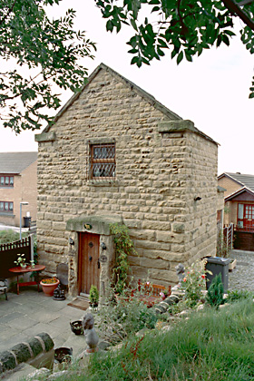
The lock-up at Cartmel is now part of a holiday complex and is PRIVATE PROPERTY.
It is situated at Wharton Barn,The Square, LA11 6QF. Nothing is known of its history.


CARTMEL


Photo's by flipflopnick
 With expressed permission
 
Many thanks to Nick for allowing me to copy his photographs.
 
 
PLEASE RESPECT PRIVATE PROPERTY


ooooooooooooooooooooooooooooooooooooooooo


The lock-up at Hawkshead is incorporated into the Market Hall of 1790. It has one cell built behind the rear wall of the lower hall. The building was also used as a court room.


HAWKSHEAD
 
Photo's by Paul Gregson with expressed permission


I am grateful to Paul Gregson for the following information and for allowing me to copy his Flickr photographs.


"The Market Hall, was built in 1790, to serve the weekly markets as a "Shambles", or covered market place, for butchers etc. The ground floor arches were originally open to the square and the elements ! The first floor consisted of the Assembly Room, (in the centre,) and on either end two dwellings, the rents from which were to pay for the buildings up keep. The building was used as the local court house, and has within it's walls the original cell or lock-up.

In 1887, for Queen Victoria's Diamond Jubilee, the western cottage was removed to allow the Assembly Room to be extended. In 2011-2012 the building is once again being restored, as part of the present Queens jubilee celebrations".


The lock-up is shown on this plan at lower rear of the building


ooooooooooooooooooooooooooooooooooooooooooooooooooo 


The lock-up at Keswick is situated at the rear of the Moot Hall in the Market Place, CA12 5JR. It is a Grade 11* listed building and a Scheduled Ancient Monument. It was originally built in 1571, rebuilt in 1695, whilst the present building dates to 1813. This was probably the time when the lock-up was constructed as well as a court  room. It is now the town TIC.


KESWICK

OS Grid Reference: NY2663223436
OS Grid Coordinates: 326632, 523436
Latitude/Longitude: 54.6008, -3.1372
Photo by Graham Hogg.
© Copyright Graham Hogg and licensed for reuse under this Creative Commons Licence 
 
I am grateful to Graham for the use of his Geograph photograph.
 
ooooooooooooooooooooooooooooooooooooooooooooooooooooo
 
 
The lock-up at Workington is a more conventional lock-up. It is situated in Ritson Street, CA14 4BP and has a datestone of 1825. An inscription over the door reads:
BUILT BY SUBSCRIPTION IN 1825.
ANNUAL GROUND RENT TWO SHILLINGS
FOR EVER.


WORKINGTON

OS Grid Reference: NY0049528486
OS Grid Coordinates: 300495, 528486
Latitude/Longitude: 54.6416, -3.5433

Photo's by Jeff Wilson
 It was Grade 11 listed 13.12.1985 (No.72295) and described as :
 Lock-up, now storeroom. Dated and inscribed over entrance BUILT BY SUBSCRIPTION IN 1805 ANNUAL GROUND RENT TWO SHILLINGS FOR EVE .... (remainder weathered away). Snecked calciferous ashlar with barrel-vaulted roof of same material. Single storey, 2 bays. Plain boarded door in plain opening and similar blocked doorway to right. Left return wall has plank door in brick surround; both return walls have slit vents. Workington is known to have had a lock-up, but no records state where it was, although this can be the only explanation of this unusual building
Source: English Heritage
Listed building text is © Crown Copyright. Reproduced under licence.


.
 
On 6th June 2008, Allerdale Borough Council issued a news release :
" Allerdale Borough Council has unveiled the latest piece of artwork in Workington to be installed under the town’s regeneration scheme.
Local artist Richard Wood has created a pair of stainless steel cell doors for an old lock-up or round house building on Ritson Street, behind the Jailhouse pub.
The grade two listed premises was originally built to be the town’s first custody cells in 1825. It housed two cells which were used to lock people up who had been arrested overnight, ready for their appearance in the magistrates’ court in the morning.
To commemorate its history, Richard has also painted a life-size image of a prisoner onto a sheet of aluminium, which peers out from a mesh screen at passers-by.
Richard said he had already received some good responses from people who have seen the art installation and know of the site’s past use. He said: “The reaction has been very good. The cell doors reflect the history of the building and the figurative artwork inside the cell complements them. It explains the use of the building rather than just using signs.”
The project took 18 months to complete and includes designs on the cell doors featuring documents covering original land deeds from the old Curwen estate, which Richard researched ".
 
Pat Martin from Workington & District Civic Trust has researched this lock-up :

“ The Old Lock-up or Round House in Ritson Street was, as the inscription above the door tells, built by subscription in 1825. Its annual ground rent is two shillings for ever. In it prisoners were confined whilst awaiting their trial.
An indenture dated 25th September 1825 referred to the lease of land in RitsonStreet, ‘on lease for a year between the town council and Mr Alan McGaa for five shillings of lawful money of Great Britain. All that piece parcel of ground situated in Upper Gate in Workington in part built upon the south end of the street there called Washington Street on the east side thereof and opposite the new church adjoining a cross street on the south. Sizes and measurements to the inch, 80’ 8” x 33’ 10”.Deed: A building to be used from the time of erecting for the sole use and purpose of lock up house for the yearly rent of 2/- (1/- at Whitsuntide and 1/- at Martinmas each year. …. for ever in trust for the inhabitants of Workington’.
The lock-up was in use until 1850 when it was sold.
They were very casual and easy-going in those early days. A tale is told that on one occasion when the constable had locked his prisoner up for the night with everything, as he thought, in order, the constable was surprised on visiting the prisoner in the morning to find him worse for liquor. The solution to this mystery was simple for it was discovered that one of the prisoners ‘cronies’ during the night has put the stem of a long clay tobacco pipe through the key-hole and pouring comfort in to the bowl, the captive sucked away to his heart’s content.
In an old diary kept by someone in Workington early in the 19th century, under the date May 28th 1827 occurred the item 'the stocks were taken to the Round House, after many consultations as to where to put them, they were made portable and brought out when required'.
In 1901 Workington boasted 87 pubs and 5 beer houses. In the previous century there were even more, keeping the constable busy wheeling drunks to the lock-up in a handcart.”
 
I am very grateful to members of Workington & District Civic Trust, Jeff Wilson for sending me the photographs and Pat Martin for sharing her research with me.
Pat has confirmed the date of the lock-up as 1825 and tells me that it is now in PRIVATE OWNERSHIP and the key may be available at the nearby Washington Hotel.

 
PLEASE RESPECT PRIVATE PROPERTY


oooooooooooooooooooooooooooooooooooooooooooooooooooooooo


DURHAM & NORTHUMBERLAND. Lock-ups at Barnard Castle, Staindrop, Morpeth & Stamfordham.


Two lock-ups are recorded in Durham and two in Northumberland.
 
 
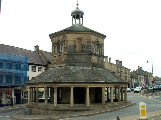
The lock-up at Barnard Castle in Durham is situated within the Butter Market,
Market Place, DL12 8NB.
The building dates to 1747 and the piers supporting the upper structure
were enclosed at some stage to form the lock-up.
The building was Grade 1 listed 24.2.1950 (No.388754),


BARNARD CASTLE

OS Grid Reference: NZ0503216330
OS Grid Coordinates: 405032, 516330
Latitude/Longitude: 54.5422, -1.9237


Photo by Roy Pledger.


oooooooooooooooooooooooooooooooooooooooooooooooooooooooooo


The lock-up at Staindrop in Durham is attached to the village church.
Nothing is known about its history.


STAINDROP
 
Photo by Roy Pledger.


oooooooooooooooooooooooooooooooooooooooooooooooooooo


The lock-up at Morpeth in Northumberland is situated at the foot of the Clock Tower,
Oldgate, NE61 1QF and it dates to the 17th century.


MORPETH
 
OS Grid Reference: NZ1976885952
OS Grid Coordinates: 419768, 585952
Latitude/Longitude: 55.1675, -1.6912
 
Photo by Miss Steel on Geograph
 
© Copyright Miss Steel and licensed for reuse under this Creative Commons Licence.
 
 
It was Grade 11* listed 11.8.1950 (No.238760) and described as :
 
Belfry and clock tower; ground floor formerly used as lock-up. Probably early
C17 re-using earlier masonry. Top floor added 1705. Squared stone. 3 storeys,
70 ft. high by 25 ft.square.
Listing NGR: NZ1976885952

Source: English Heritage
Listed building text is © Crown Copyright. Reproduced under licence.
 
 
ooooooooooooooooooooooooooooooooooooooooooooooooooooo


The lock-up at Stamfordham is situated on The Green, Grange Road, NE18 0PB.
It dates to the early 18th century with an earlier core.


 STAMFORDHAM
 
OS Grid Reference: NZ0791372061
OS Grid Coordinates: 407913, 572061
Latitude/Longitude: 55.0430, -1.8777
 
Photo by Alexander P Kapp with expressed permission.
 
I am grateful to Alexander for allowing me to use another of his photographs.

 
It was Grade 11 listed 28.4.1969 (No.238873) and described as :

Lock-up. Early C19 with earlier core. Tooled-and-margined ashlar with stone
slate roof. A single-storey, small rectangular building with studded door in
the gable end. 4 ventilation slits above door and one on either side.
Stone eaves. Gabled roof with kneelers.Interior has stone roof supported by
large square central pier. Chains attached to the walls.
Listing NGR: NZ0791372061
Source: English Heritage
Listed building text is © Crown Copyright. Reproduced under licence: PSI Click-use licence number C2008002006


oooooooooooooooooooooooooooooooooooooooooooooooooooooooooooo


Thursday 28 March 2013

YORKSHIRE. Lock-ups at Holme on Spalding Moor, Wath on Dearne, Rotherham and Wakefield.


This lock-up at Holme on Spalding Moor in The East Riding of Yorkshire, is situated at Workhouse Farm, Howden Road, YO43 4BT and is now PRIVATE PROPERTY.
This interesting round tower building dates to c1790 and was for use with women from the adjacent workhouse. There was a similar structure for men which has been demolished.


HOLME ON SPALDING MOOR

OS Grid Reference: SE8083636794
OS Grid Coordinates: 480836, 436794
Latitude/Longitude: 53.8211, -0.7735

Photo courtesy of Peter Higginbotham
(www.workhouses.org.uk)

I am grateful to Peter Higginbotham for allowing me to copy this photograph.


It was Grade 11 listed 28.8.1987 (No.164982) and described as :

Lock-up. C1790. Brick in Flemish bond, plain tile roof. Circular on plan and approximately 5 metres in height. Small slit windows to upper part of wall. Dentilled cornice.

Source: English Heritage
Listed building text is © Crown Copyright. Reproduced under licence.


PLEASE RESPECT PRIVATE PROPERTY


OOOOOOOOOOOOOOOOOOOOOOOOOOOOOOOO


The two storey parish lock-up at Wath on  Dearne in South Yorkshire has been converted
into a dwellinghouse whilst retaining many of its previous characteristics, and is now 
PRIVATE PROPERTY. It is situated at 27 Thornhill Place, S63 6SL and dates to c.1800.
The lock-up was on the ground floor with constable's accomodation above.


WATH ON DEARNE
 
OS Grid Reference: SE4316800871
OS Grid Coordinates: 443168, 400871
Latitude/Longitude: 53.5028, -1.3506
 
 
The lock-up has been fully renovated as a private house, whilst retaining many
of its original characteristics, by the present owner Mark Benton


The lock-up before it was renovated.
 
 
It was Grade 11 listed 10.10.1973 and described as :
 
Photo by rotherhamweb with thanks
 
 
Lock-up. Early C19. Coursed, rock-faced sandstone; stone slate roof.
Small, 2-storey building in rugged style. Plinth; deeply-coursed
ground-floor walling. Gable front: studded oak door in porch with
monolithic jambs and pediment-shaped monolithic slab roof. Window
above (now bricked-up) has rock-faced sill and lintel. Heavy rock-faced
kneelers and gable copings. End stack to left. Damaged roof. Rear:
stair projection with separate doorway and slab roof.

Interior: 2 cells with ashlared walls pierced by small light holes.
Stone toilet to each cell. Constable's room on 1st floor has fireplace '.

Source: English Heritage
Listed building text is Crown copyright. Reproduced under licence.


Postcards of the lock-up prior to conversion to dwelling


Website www.oldparishlockup.co.uk relates :
 
  The lock up was built around 1800.
It was used by constable to provided secure temporary accommodation until drunks and troublemakers could be moved to Rotherham.
 It comprised two small, windowless, stone cells, whose separate padlocked doors lay immediately behind a nail-studded front door. It has a stone staircase at the back which led up to the constable’s simple room above the cells.
William Woollen was constable in 1849.
The last village constable was William Thomas in the mid-nineteenth century.
Their duties as Constable were extensive, paying lame soldiers of the parish and making sure wandering beggars did not become a burden on the village.
It is believed that the Parish lock up was not used after 1837.
 
In 1881 a 52 year-old widow, Rose Awty, lived in the lock-up. Her husband William had been a licensed hawker. He was a local man but Rose was born in Burton on Trent.
In 1922 Charles Godfrey Woodhead rented the top floor from Mr. Blackburn of Thornhill and wanted to “turn this into a habitable cottage” .


The solid stone porch has been retained


Cell door still in use


The constables fireplace has been retained


With many thanks to present owner Mark Benton for allowing me to copy photographs and information from his web site www.oldparishlockup.co.uk


PLEASE RESPECT PRIVATE PROPERTY


OOOOOOOOOOOOOOOOOOOOOOOOOOOOOOOOOOOOO


This lock-up at Rotherham in South Yorkshire, was situated in the Chapel of Our Lady (Bridge Chapel), Bridge Street, S60 1RB which dates to 1483 and is a Grade 1 listed building. The chapel was used as a lock-up in 1779 before becoming a private house in 1826. The doors to the lock-up are still preserved in the undercroft.


ROTHERHAM
 
Photo by Stanley Walker on Geograph
 © Copyright Stanley Walker and licensed for reuse under this Creative Commons Licence
 
 
The chapel was Grade 1 listed 19.10.1951 and described as :
 
Bridge chapel. 1483, exterior restored 1924, interior restored 1980. Deeply-coursed, ashlar sandstone; roof not visible. Small gable-entry building set on north side of Rotherham Bridge (q.v.).  Interior: unimproved undercroft with remains of cell doors. C20 interior. Probably founded by Archbishop Thomas Rotherham. In 1483 John Bokying bequeathed 3s 4d to the fabric of the chapel to be built on Rotherham Bridge (Hey). Used as an almshouse before serving as town jail in 1779 (doors preserved in undercroft), used as private house from 1826 but became tobacconist's shop from 1888-1913. Reconsecrated 1924. D. Hey, 'Rotherham Bridge', Archaeological Journal, vol 137, 1980, p430. P. F. Ryder, Medieval Buildings of Yorkshire, 1982, p82 (plate).
 
Source: English Heritage
Listed building text is © Crown Copyright. Reproduced under licence.


oooooooooooooooooooooooooooooooooooooooooooooo


This lock-up at Wakefield in  West Yorkshire, was also situated in a chantry chapel on the old bridge over the River Calder on the A61, WF1 1US.  It is also Grade 1 listed and dates to the mid 14th century. Together with Rotherham it is one of only four such bridge chapels remaining in the country.
At the Dissolution the chapel fell into secular use and was variously used for commercial purposes.
Although details are sparse, at some stage it became a lock-up when the small crypt was used as a cell and the main body of the chapel was used by the constable.


WAKEFIELD

 OS Grid Reference: SE3382320140
OS Grid Coordinates: 433823, 420140
Latitude/Longitude: 53.6766, -1.4894


Photo by Roy Pledger


oooooooooooooooooooooooooooooooooooooooooooooooo


YORKSHIRE. Lock-ups at Rastrick, Slaithwaite, Snaith and Thorp Arch.


The lock-up at Rastrick in West Yorkshire was situated in the basement of the Local Board Offices at the corner of Ogden Lane and Stackgarth.


 RASTRICK
 
Photo by Humphrey Bolton.
 
 
Stackgarth, a short unmade street off Ogden Lane. The house on the left was the offices of Rastrick Local Board from 1863 until the formation of Brighouse Borough in 1893. The village lock-up was in the basement, so the blocked doorway (at the extreme left of the photograph) probably led down to it.

  © Copyright Humphrey Bolton and licensed for reuse under this Creative Commons Licence.
 
I am grateful to Humphrey Bolton for the use of his Geograph photograph and comments.


oooooooooooooooooooooooooooooooooooooooooooooooooooooooooooooooo


 The lock-up at Slaithwaite in West Yorkshire is situated within the precincts of
the Manor House, Church Street, HD7 5AS and dates to 1831 (datestone).
It contains a single cell and has no windows.
Apparently it was never used.


SLAITHWAITE
 
National Grid Reference: SE 07758 13995
 
Photo by Stanley Walker on Geograph
© Copyright Stanley Walker and licensed for reuse under this Creative Commons Licence


It was Grade 11 listed 11.7.1985 (No.1233459) and described as :

1831. Single cell building. 1 storey. Flat roof with crenelated parapet. Ashlar with rusticated quoins. South facing door with large stone lintel with shallow false arch with inscription.
Lock-up.
Erected by subscription 1831.

Source: English Heritage
Listed building text is © Crown Copyright. Reproduced under licence.


ooooooooooooooooooooooooooooooooooooooooooooooooooo


The lock-up at Snaith in The East Riding of Yorkshire,  is situated in the Butter Market, DN14 9HN, alongside the church wall.  It has two cells and dates to the late 18th/early 19th century. It is known locally as the 'Penny Cells' due to the fact that incumbents had to pay 1d to the Constable following their pleasure at being incarcerated therein.  


SNAITH
OS Grid Reference: SE6413222178
OS Grid Coordinates: 464132, 422178
Latitude/Longitude: 53.6921, -1.0303
 
 
Photo by Roy Pledger

 
It was Grade 11 listed 23.4,1952 (No..164908) and described as :

Former lock-up. Late C18-early C19, with later alterations to roof of left cell. Built by the Vestry Board for the use of the Manor Constables. Brown brick with sandstone ashlar dressings. Pantile roof. Plan: 2 rooms, each with entrance to street. Single storey, 2 windows. Doorways with ashlar jambs and lintels and original heavy studded oak board doors, flanked by small single windows with ashlar surrounds and 6 vertical iron bars with single cross-bar. Swept roof to cell on right; later single-pitch roof to cell on left (collapsed at time of resurvey). Interior: cell to right retains original sandstone ceiling. Former boiler house adjoining to rear, and fire-station addition adjoining to right, are not of special interest. An unusual and important survival, empty and partly derelict at time of resurvey.

Source: English Heritage
Listed building text is © Crown Copyright. Reproduced under licence.


The building has been preserved by Snaith and District Heritage Society who have produced a leaflet outlining some of the history of the building :


ooooooooooooooooooooooooooooooooooooooooo


Very little is known about the lock-up at Thorp Arch in West Yorkshire.
It is situated in Church Causeway, LS23 7AH, at the junction with Whins Lane, alongside All Saints church.


 THORP ARCH
 
Photo's by Roy Pledger.


ooooooooooooooooooooooooooooooooooooooooooooooooooooooooooooooo

Wednesday 27 March 2013

YORKSHIRE. Lock-ups at Illingworth, Luddenden and Seamer.


The lock-up at Illingworth in West Yorkshire is situated at 121 Keighley Road, HZ2 8HY and is on a double bend of the busy A629 road. It dates to 1823 (datestone) and has the distinction of being Grade two star listed and a building on English Heritage's at risk list. This is a fine substantial building and should be saved.


ILLINGWORTH

OS Grid Reference: SE0707728395
OS Grid Coordinates: 407077, 428395
Latitude/Longitude: 53.7519, -1.8941


It was Grade 11* listed 3.11.1954 (No.338739) and described as :


Dated 1823. Small 2-storeyed stone building with stone roof. Central, round-
arched and rusticated doorway with lunette over and date tablet above inscribed
'Let him that stole steal no more but rather let him labour with his hands
the thing which is good that he may have to give to him that needeth.' Small
(later?) window each side. Flanking broad strip pilasters pierced by rusticated
circular windows. Cornice and blocking below eaves. Modern ventilator to
roof. Cottage adjoins east side .

Source: English Heritage
Listed building text is © Crown Copyright. Reproduced under licence.


A plaque above the door is inscribed :

'Let him that stole steal no more
But rather let him labour with his hands
The thing which is good that he may
Give to him that needeth.
Erected AD 1823'.


In July 2010, an article appeared in the Halifax Courier :

OLD JAIL IS ADDED TO LIST OF AT RISK BUILDINGS

" A former jailhouse has been added to the list of historic and architectural buildings "at risk" in Calderdale.
The Grade 2* listed lock-up in Keighley Road Illingworth, Halifax – pictured – dates from 1823 and is described by English Heritage as in very bad condition.
It is owned by Calderdale Council which had planned to sell at auction but a local campaign began last summer to try to save it.  Ward councillor Barry Collins (Lab) said: "We managed to get it withdrawn from auction while we seek a grant to carry out the necessary repairs and try to develop ideas for the future use of the building."


The old stocks are preserved in an area alongside the lock-up


The Stocks


Photographs by Roy Pledger


ooooooooooooooooooooooooooooooooooooooooooooooooooooooooooo


The lock-ups at Luddenden in West Yorkshire are a little unusual in that they are inscribed on the door lintels 'Midgley' and 'Warley' and for the use of those respective townships, the boundaries of which met at Luddenden Brook. They are situated in the basement of the former Junior School in High Street, HX2 6PX and date to c1825. The distant photograph shows the outline of what may have been a third doorway and although it is not inscribed I wonder if it may have been Luddenden's own lock-up?


 LUDDENDEN
 
 OS Grid Reference: SE0409026149
OS Grid Coordinates: 404090, 426149
Latitude/Longitude: 53.7317, -1.9395

 
The school building was Grade 11 listed 19.7.1988 (No.339232) and described as :
 
 School. 1825, enlarged 1856, restored and extended 1928 (date plaques), further
extended mid C20. Coursed, squared watershot stone; stone slate roof. 2 storeys with
basement. 2 x 6 + 3 + 3 bays. Gable (road) front: openings have plain stone
surrounds. Basement: right hand bay has 3 doorways, one blocked, the other 2 with old
board doors the lintels inscribed 'MIDGLEY' and 'WARLEY' (gave access to 2 lock-ups
for the use of the respective townships (which meet at Luddenden Brook)) .

Source: English Heritage
Listed building text is © Crown Copyright. Reproduced under licence.


Maybe the outline of the third doorway led to another lock-up?
 
 
' The constable maintained law and order. Offenders might be put in the village stocks where they would be laughed and jeered at, or later in cells which were built underneath the school in 1825. Stray animals, or those seized for non-payment of fines or debts, were put in the township pinfold. Cells for offenders built below the village school. People from Midgley or Warley Townships were put in the appropriate cell. Sometimes, punishments for minor crimes could be very harsh '


ooooooooooooooooooooooooooooooooooooooooooooooooooo.


It would appear that a garden gazebo built into the wall of Stainley Hall,
at North Stainley, HG4 3HT was also used as a lock-up.

OS Grid Reference: SE2874176666
OS Grid Coordinates: 428741, 476666
Latitude/Longitude: 54.1850, -1.5611


It was Grade 11 listed 21.2.1985 (No.331100) and described as :
 

2/96 Gazebo
(formerly listed as
21.2.85
former Village Lock-up,
North Stainley)

Gazebo. Early - mid C19. Probably for the Staveley family of Stainley Hall
(qv). Coursed limestone rubble and cobbles, sheet metal roof. A circular
1-storey building entered from the south side and built into a garden wall.
Sawn stone door surround lacking any door fittings. Small square windows on
the north and east sides, giving a view up and down the main street of North
Stainley. Tall conical roof. Wooden finial. Interior: plain plaster
walls, braced timber roof structure.
Listing NGR: SE2874176666


Source: English Heritage
Listed building text is © Crown Copyright. Reproduced under licence: PSI Click-use licence number C2008002006.


oooooooooooooooooooooooooooooooooooooooooooooooooooooooo


Little is known about the lock-up at Seamer in North Yorkshire.  It is situated in the Main Street, YO12 4PS near to the junction with Stocks Hill. It has been converted in to a barber's shop.


 SEAMER

Photo's by Roy Pledger


ooooooooooooooooooooooooooooooooooooooooooooooooooo