Sunday 28 April 2013

GLOUCESTERSHIRE. Lock-ups at Lechlade, Stroud and Westerleigh.


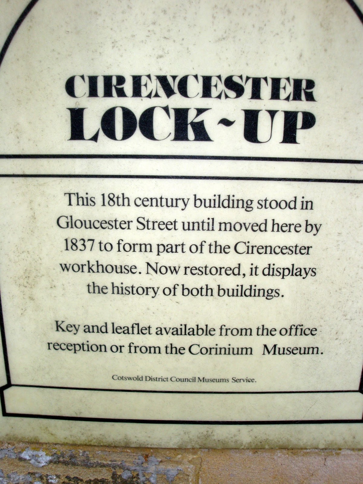
There are three further lock-ups in Gloucestershire which fall into the 'probables' category.

There is sparse information about possible lock-ups at Lechlade. It is thought that the lower half of the toll house on Halfpenny Bridge may have been a lock-up but no further information has been forthcoming.

LECHLADE

OS Grid Reference: SU2133899346
OS Grid Coordinates: 421338, 199346
Latitude/Longitude: 51.6925, -1.6927

Photo by Dr Neil Clifton

© Copyright Dr Neil Clifton and licensed for reuse under this Creative Commons Licence

I am grateful to Dr Clifton for ther use of his Geograph photograph.


The Bridge and Toll House were Grade 11 listed 9.2.1958 (No.129072) and described as :

Roadbridge carrying Thames Street (A361) over River Thames and toll
house. 1792, when Thames Street laid out. Dressed stone. Bridge
about 6m wide with coped wall about lm high following considerable
arch of bridge and splaying out at each corner. Roadway from toll
house to centre district boundary line about 10m. Single large
semi-circular arch approximately 8m high at apex, with straight
large roll moulded string course over. Side piers each have blind
round oculus and very small semi-circular arches at base. Toll
house on north east corner, small square of 2 storeys with basement
and road-level room in coursed stone with asbestos slate pyramidal
roof and brick stack to east. Large roll moulded string course
between floors. Square window openings to south and north and door
to west straight on to bridge. Said to be named after the
halfpenny toll levied until 1839
.Listing NGR: SU2133199328

 Source: English Heritage
Listed building text is © Crown Copyright. Reproduced under licence.

It is also thought that there may also have been a lock-up as part of the old fire station in Burford Street but again no further information has been forthcoming.


ooooooooooooooooooooooooooooooooooooooooooooooooooo


It appears that there was a lock-up in the basement of the 16th century town hall at Stroud, but once
again no further information has been forthcoming.  


STROUD
 
Photo by Roy Pledger
 
oooooooooooooooooooooooooooooooooooooooooooooooooooooooooooooo


It is said that the village lock-up at Westerleigh was situated at the foot of the tower of St James' church and once again no further information  has been forthcoming.


ooooooooooooooooooooooooooooooooooooooooooooooooooooooooo
Any information and photographs in connection with these three would be greatly appreciated.


Saturday 27 April 2013

GLOUCESTERSHIRE. Lock-ups at Moreton in Marsh, North Leach and Thornbury.


The lock-up at Moreton-in-Marsh is situated at the foot of the Curfew Tower in the High Street, GL56 0AX and probably dates to the 16th century, being the oldest building in the village.


MORETON IN MARSH
 
OS Grid Reference: SP2048632445
OS Grid Coordinates: 420486, 232445
Latitude/Longitude: 51.9901, -1.7031
 
Photo's by Roy Pledger
 
 
It was Grade 11 listed 25.8.1960 (No.126691) and described as :
 
Probably C16. Ancient stone rubble tower of 2-storeys. Arched window above
4 canted arched doorway. Interesting C17 clock. Curfew bell in gabled turret.
Said to be the oldest building in Moreton-in-the-Marsh. Formerly used as lock-up,
see Tudor-arch doorway with shielded door at south-west corner.
 Listing NGR: SP2048632445

 Source: English Heritage
Listed building text is © Crown Copyright. Reproduced under licence.


ooooooooooooooooooooooooooooooooooooooooooooooo


The lock-up at North Leach is situated adjacent to the post office in Market Place, GL54 3EE and dates to the 17th - mid 18th century. Part of the post office building, it has
an eight feet sqaure cell with a stone barrel roof.


NORTH LEACH
 
OS Grid Reference: SP1129314595
OS Grid Coordinates: 411293, 214595
Latitude/Longitude: 51.8299, -1.8375
 
Photo by Nina J G
 
© Copyright Nina J G and licensed for reuse under this Creative Commons Licence
 
I am grateful to Nine JG for the use of her Flickr photograph.
 
 
It was Grade 11 listed 23.1.1952 (No.130451) and described as :
 
The Post Office and lock-up, at end of row. C17-mid C18 in several
phases. Main body limestone rubble. Twin-gabled extensions at
front. Coursed squared and finely dressed limestone, rendered at
front above ground floor level. Ashlar stacks replaced in brick.
Complex plan with two gabled extensions projecting forwards at
front. C20 lean-to shop front with glazing bars, C20 door with
glazing bars left. Four 12-pane sash windows to first floor;
those lighting right-hand gable paired. Attics lit by 2-light
casements with glazing bars. Keystone to first floor and attic
window of left-hand gable. Projecting shop window with horizontal
glazing bars to left-hand return of left-hand gable. Early plank
door giving access to former 'lock-up' left where the stocks and
ducking stool were formerly stored. Heavy-pegged frame with lintel
with ogee curved soffit. Axial stacks. Interior not inspected.
Listing NGR: SP1129214594
 
Source: English Heritage
Listed building text is © Crown Copyright. Reproduced under licence.


ooooooooooooooooooooooooooooooooooooooooooooooooo


The lock-up, with animal pound, at Thornbury is situated in Church Road, BS35 1HJ near the church and dates to the early 19th century. There is a clear image on Google Street View and the property may be in private ownership - the pound now seems to be a walled garden complete with greenhouse.


THORNBURY

OS Grid Reference: ST6346490621
OS Grid Coordinates: 363464, 190621
Latitude/Longitude: 51.6132, -2.5290

 
Photo by John Grayson


© Copyright John Grayson and licensed for reuse under this Creative Commons Licence
 
I am gratefult to John Grayson for ther use of his geograph photograph.


It was Grade 11 listed 17.12.1984 (No.34929) and described as :
 
 Early C19. Lockup. Coursed rubble. Modern tiled roof. One storey. Two slit
windows, high up. Gabled projecting porch and 4-centred arch headed plank door.
Behind is Pound: 3 rubble walls (4th is rear of lock-up), approx 5 ft high. Gate in centre of
south wall, small embraser to left of gate.
Listing NGR: ST6346490621

 Source: English Heritage
Listed building text is © Crown Copyright. Reproduced under licence.


ooooooooooooooooooooooooooooooooooooooooooooooo


GLOUCESTERSHIRE. Lock-ups at Bibery, Bisley, Bitton and Cirencester.


There is a varied collection of existing lock-ups in Gloucestershire.

Thanks to Richard Williams at the post office in Bibery I am able to record details of the lock-up there. It is situated on the B4425 near to the Swan Hotel, GL7 5NP and dates to the late 18th century.


BIBERY


OS Grid Reference: SP1146806956
OS Grid Coordinates: 411468, 206956
Latitude/Longitude: 51.7612, -1.8352


Photo's by Richard Williams


It was Grade 11 listed 5.2.1987 (No.127251) and described as :
 
 
Village lock-up. Late C18. Ashlar limestone; stone slate roof.
Hexagonal plan. Plain front doorway with heavy studded door.
Small square opening in rear wall with heavy vertical iron bars.
Plain eaves band. Hipped roof. Interior not inspected.

Listing NGR: SP1146806956
 
 Source: English Heritage
Listed building text is © Crown Copyright. Reproduced under licence.


In his 'Tales from Bibery Shop' blog, Richard Williams relates: 

" Prior to the 1839 County Police Act, sometimes known as the Rural Police Act, most villages of any size had a 'lock up', where law breakers could be detained prior to a court appearance.  The Act allowed for the appointment of a professional police constable, rather than the part time Parish constable, to be employed 'for the preservation of the peace and protection of the inhabitants'.  It also stipulated that a police house had to be constructed, along with appropriate cell accommodation.  The Old Police House is up on the Cirencester road in Arlington and looks as if it was built around the time of the Act.  However, the photo above is of the lock up.  It must have been a grim place to have spent anytime at all, never mind a cold winter's night.  The only window is a very small one to the rear which is heavily barred and the door is hugely thick and riveted.  It looks a little unloved at the moment, but it would be fascinating to find out who has languished within and why they were there!" "


ooooooooooooooooooooooooooooooooooooooooooooooooooooooooo


The very unusual lock-up at Bisley is situated at 3 George Street, GL6 7BB and has two cells which are now covered by iron gates. It dates to 1824 (datestone) and was restored in 1999.


BISLEY

OS Grid Reference: SO9035406054
OS Grid Coordinates: 390354, 206054
Latitude/Longitude: 51.7531, -2.1411

 
Photo's by Roy Pledger
 
 
It was Grade 11 listed 28.6.1960 (No.132609) and described as :
 
 Village lock-up. Dated 1824. Ashlar limestone front; coursed
rubble to sides and rear; stone slate roof. Single-storey with 2
cells; small walled forecourt. Ogee-shaped parapet to front gable
with ball finial. Two square-headed openings with C20 restored
iron gates; lunette of same width set immediately above stone
lintel to each opening with iron grid-iron filling. Raised oval
datestone set centrally above. Plain sides and rear. Low
forecourt walls with central gate opening (gate missing) has plain coping.
Interior: oval stone tunnel-vaulted ceiling to each cell. A very
well preserved example of this building type.

Listing NGR: SO9035406054

Source: English Heritage
Listed building text is © Crown Copyright. Reproduced under licence.
 
A plaque on the wall tells us:


The village web site tells us : 
"The Lock-Up was built as the village prison in 1824 to replace the previous prison that had become unusable, which had been sited for centuries in the Church Yard.  When the new Lock-Up was originally built it would have boasted heavy solid wooden doors, that have longsince decayed.
Law and order was upheld by the local Magistrate, and also through the Church, a powerful force in those days. There were no official Police, the Gloucestershire Constabulary was only founded in 1836, but local men were appointed as village Constables. They were usually men who were sufficiently big in stature, and of good character.
Bisley, around this time – 1824, was a poor place indeed. The gentry were few in number and had a reasonably pleasant existence in their large houses and with horses and carriages to get around. For the ordinary folk poverty was all too common. The industrial revolution had taken work away from the cottage weavers, and those still in work were being paid less than a quarter of the wages they’d earned twenty years before.
Bisley at the crossroads of the Cheltenham Road and the route to Cirencester was becoming increasing less popular to traders and visitors because of the difficult hills and roads, and the weekly market here had all but died out.
The Workhouse, at Joiners Lane, was full of folk who could not provide for themselves, and conditions there were wretched. Crime and prostitution were rife, and drunkenness was made all the more easy by the large number of Ale Houses in the village.
Punishment was cruel; the Lock-up held prisoners long enough to be put before the Magistrate, or drunks overnight to sober up. Then followed the options of a fine, or a spell in the Stocks or the Pillory – and this was for the most petty of offences. More serious crime such as stealing or assault would see the prisoner sent to Horsley where there stood a large prison known as the House of Correction. Hard Labour was inflicted by 20 minute spells on the massive treadmill, that prisoners took in turn a dozen or so at a time, for up to 16 hours a day.
Those who were sent to the Court of Assize, or the Court of Quarter Session faced severe sentences, where death by hanging was common. Others; men, women and children, were transported by the Navy to Australasia for periods of seven years or life. Many died in horrendous conditions, held like slaves, during the crossing. None returned.
The lock-up was restored to its current good condition in 1998, with Heritage Lottery funding, and the restoration was marked by a specially written Mummers Play, performed in the road in front of it
(a photo of which is on display in The Bear)".

Last Updated ( Friday, 05 October 2007 ).
http://www.bisleyonline.net/content/view/21/67/


oooooooooooooooooooooooooooooooooooooooooooooooooooooooooooooooo


A cottage at 162 High Street, Bitton, BS30 6LB, formerly Bath Road,
bears the title 'The Old Lock-up'.
(Google street view)

OS Grid Reference: ST6820369570
OS Grid Coordinates: 368203, 169570
Latitude/Longitude: 51.4242, -2.4587


Prior to 1834 this was the site of a 'Poorhouse' and 'Pin Factory' and the two adjoining cottages were the house of the village constable and the village lock-up. (154-162 Bath Road).


The site was Grade 11 listed 15.7.1981 (No.28485) and described as :

C18. Two storeys, vernacular row in mixed lias and pennant-stone rubble.
Two cottages with single pitched pantile roofs, rest with mansards. Two
windows per cottage, 2-light casements with plain chamfered stone mullions
(long mullions on ground floor), thin cornices over ground floor windows
of 1st 2 cottages, continuous weathered string over remaining 3 plain
chamfered door openings. Features appear restored, the windows of Nos
158 and 162 are modern casements.
Said to have been built as late as 1767. The mansard roofed cottages were
a poor house and pin factory. The 2 cottages to east were once the village
constable's house and lock-up.
Listing NGR: ST6820369570


Source: English Heritage
Listed building text is © Crown Copyright. Reproduced under licence.


DO YOU HAVE A PHOTOGRAPH OF THIS LOCK-UP PLEASE


ooooooooooooooooooooooooooooooooooooooooooooooooooooooooo


The lock-up  at Cirencester is now situated in the grounds of the Cotswold District Council Offices in Trinity Road, GL7 1RP, in buildings which formed part of the former town workhouse. There is public access and a key to the lock-up, together with an information booklet can be obtained from the main office.  The lock-up has two cells with vaulted roofs and wooden benches. It dates to 1804 and was originally built in Goucester Street by a local builder at the cost of some £60. Eventually It fell into disuse and in 1837 it was moved, stone for stone, to it's present site where it was used as a 'refractory ward' by the workhouse. Now fully restored.


CIRENCESTER

OS Grid Reference: SP0239001466
OS Grid Coordinates: 402390, 201466
Latitude/Longitude: 51.7119, -1.9668

 
Photo's by Roy Pledger


It was Grade 11 listed 23.7.1971 (No.365459). It is described as :

Lock-up. C18. Limestone ashlar; limestone ashlar centreless vaulted roof. Rectangular plan. Two C20 plank doors in plain reveals to N facing long side; small window with wrought iron grille with chamfered reveal to each short side. Shallow plinth. INTERIOR not Inspected; said to be divided into 2 cells with later doors. Lock-up originally sited in Gloucester Street, moved to present site on erection of workhouse, now Cotswold District Council offices, in 1837.
Listing NGR: SP0239001466

 Source: English Heritage
Listed building text is © Crown Copyright. Reproduced under licence.
 
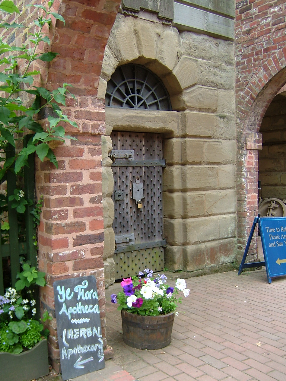
The two cells both have vaulted roofs and wooden benches.


A brochure about the lock-up is available at the Council Offices :


I am grateful to Cotswold District Council for this information.


oooooooooooooooooooooooooooooooooooooooooooooooooooooooooooooooooo

Friday 26 April 2013

WARWICKSHIRE & WORCESTERSHIRE. Lock-ups at Alcester and Bewdley..


Remaining lock-ups are a bit thin on the ground in this part of the world.


The lock-up at Alcester in Warwickshire is situated on the ground floor of the old Town Hall in Church Street, B49 5QX and probably dates to the 18th century when the open arcades were filled in to form a lock-up in the south west bay. The building actually dates to c1618.


ALCESTER

OS Grid Reference: SP0908257521
OS Grid Coordinates: 409082, 257521
Latitude/Longitude: 52.2158, -1.8685

Photo by Stephen McKay

© Copyright Stephen McKay and licensed for reuse under this Creative Commons Licence

I am grateful to Stephen McKay for the use of his photograph on Geograph.


It was Grade 11 listed 10.2.1956 (No.395224) and described as :

 Town Hall, c.1618. Ground floor.................former lock-up in south-west bay.
Listing NGR: SP0908257521

 Source: English Heritage
Listed building text is © Crown Copyright. Reproduced under licence.


ooooooooooooooooooooooooooooooooooooooooooooooooooooooo


There are three individual lock-up cells at Bewdley in Worcestershire situated in their original position in Load Street, DY12 2AS, behind the Town Hall and Shambles, now Bewdley Museum and they date to 1783 with some 20th century restoration. The original doors, which were replaced, are stored at the museum.


BEWDLEY

OS Grid Reference: SO7867875294
OS Grid Coordinates: 378678, 275294
Latitude/Longitude: 52.3753, -2.3146


Photo courtsesy of Bewdley Museum

Together with The Shambles, they were Grade 11 listed 2.10.1975 (No.156796) and described as :

Market building and prison cells, now part of Bewdley Museum. 1783 with
some late C20 restoration. Brick with tile roofs. Two parallel ranges
running back (south-east) from Town Hall (qv) with 14 bays to the north
range, 15 to the south. Bays open to front with segmental arches on square
brick piers, south-east closed by a single arch with blank wall at back.
Attached at south corner are three prison cells; two facing north-west have
rusticated ashlar surrounds, fanlights with wrought iron infill and studded
boarded doors with strap hinges. (Hereford and Worcester Record Office, BA
2432, box 3, no 49b).
Listing NGR: SO7867875294

 Source: English Heritage
Listed building text is © Crown Copyright. Reproduced under licence.


Photo courtesy of Bewdley Museum

This cell has a datestone for 1802.


"The interior of the lock-up was sparse consisting of a stone bed with a wooden board and a small grate.  Once the door was locked the cell would have been dark, poorly ventilated and the grate would have provided only a little warmth if the prisoner had been fortunate enough to persuade someone to light a fire."


Photo courtesy of Bewdley Museum 
Bewdley's pillory and stocks were also in Load Street.

"It was said that Bewdley had a high proportion of criminals, possibly due to the town having ' a smaller proportion of schools and a larger proportion of public houses than any other town in the country.' At its height Bewdley had as many as thirty public houses."

"As early as 1447 there was a lock-up in the gatehouse on the bridge, which was severely damaged by floods in 1795 and the lock-up was not replaced when a new bridge was built.
In any case in 1627 the 'New House' with a 'strong cage' was built under the old Town Hall and it was demolished in 1793. This probably coincided with the Charter by James 1 of 1605 which allowed towns to police themselves with a Constable and J.P to deal with minor offences. More serious offences were dealt with at Quarter Sessions or Assizes".
http://www.wyreforestdc.gov.uk/cms/leisure-and-culture/museums-and-galleries.aspx
 

I am most grateful to Liz Cowley of Bewdley Museum for sending me these photographs and an information leaflet about the lock-up.


oooooooooooooooooooooooooooooooooooooooooooooooooooooooooooooooooooooooo


Wednesday 24 April 2013

HEREFORDSHIRE. Lock-ups at Bosbury, Bridstow, Ross on Wye and Yarpole.


Further west in Herefordshire I have located just four former lock-ups.


ooooooooooooooooooooooooooooooooooooooooooooooooooooooooo


The lock-up at Bosbury is situated in the gatehouse to the Old Court Farmhouse, HR8 1QT,
to the left of the gateway.


BOSBURY

OS Grid Reference: SO6957743502
OS Grid Coordinates: 369577, 243502
Latitude/Longitude: 52.0890, -2.4454
 
Photo by Philip Pankhurst
 
 © Copyright Philip Pankhurst and licensed for reuse under this Creative Commons Licence
 
I am grateful to Philip Pankhurst for the use of his Geograph photograph.
 
 
The building was Grade 11 listed 26.3.1986 (No.153010) and described as :


Former gatehouse to the Old Court, now hop store. Possibly C14, greatly
altered. Sandstone rubble, tiled roof, brick C19 alterations to rear.
Gatehouse aligned north/south with central gateway, adjoining hop kilns
to north (not of special architectural interest) and former Grammar School
(qv) to south. Gateway now of two storeys, central pointed archway of two
chamfered orders (head of arch now blocked) with minor pointed arch headed
doorway of one chamfered order to left flanked by buttressing, wall extends
to south (left) with two openings to upper floor and one to lower. The room
to the left of the entrance is known locally as the jail.
(RCHM Vol II, p 20,
item 4; Watkins, J: Duncomb's Collections towards the History and Antiquities
of the County of Hereford, Hundred of Radlow, 1902, p 27; Rev S Bentley, History
of the Parish of Bosbury, 1891).
Listing NGR: SO6957743508
 
Source: English Heritage
Listed building text is © Crown Copyright. Reproduced under licence.


ooooooooooooooooooooooooooooooooooooooooooooooooooooooooooo


The former lock-up at Bridstow is situated in Wilton Lane, HR9 6AQ and is now part of the White Lion public house (Tel.01989 562785). It has been altered and its two storeys probably contained constable's accomodation. It probably dates to the early 17th century.


BRIDSTOW

Photo by Landscape Origins of the Wye Valley.
 
I am grateful to Heather Hurley of Ross & District Civic Society for sending me this photograph.
 
 
It was Grade 11 listed 18.5.1953 (No.398898) and described as :
 
BRIDSTOW CP WILTON LANE (south side) SO 5824 9/40 Old Prison 18.5.53 GV II Prison, now part of public house. Possibly early C17. Square sandstone, pantiled roof and brick end stack. Two storeys. Two windows, 2-light barred mullions each with blocked opening beneath. 
First floor of gable end has another 2-light barred mullion to left of end stack. (RCHM Vol I, p 33).
 
Source: English Heritage
Listed building text is © Crown Copyright. Reproduced under licence.


ooooooooooooooooooooooooooooooooooooooooooooooooooooo


The fine lock-up at Ross on Wye is situated in New Street, HR9 7DA and dates to 1820-1830.


ROSS ON WYE
 
OS Grid Reference: SO5987124247
OS Grid Coordinates: 359873, 224247
Latitude/Longitude: 51.9153, -2.5848
 
 
Photo by Ross & District Civic Society with permission.
 
 
I am grateful to Heather Hurley from Ross & District Civic Society for sending me this photograph.
 
 
It was Grade 11* listed 22,10,1952 (No.153571) and described as :
 
 1820-30. Formerly the old prison. Small square red sandstone building
with hipped slate roof. In front, on ground floor are high flanking pointed
windows with iron bars on 1st floor a similar window in centre with a small
blocked one on either side. Doorway has a pointed arch of 2 orders with
stone panel above. Door is studded and has a grill. Heavy wide stone pilasters
on either side.
Listing NGR: SO5987124247
 
Source: English Heritage
Listed building text is © Crown Copyright. Reproduced under licence.
 

Ross on Wye web site tells us :

In 1830 an Improvement Act was passed for "paving, cleaning, draining, lighting, regulating and improving the Town of Ross" and this meant that Ross could have Watchmen and a Lock Up containing two or more cells. The Lock Up, now known as Old Jail or 'Gaol', was then built on New Street on the site of an old stables in around 1838 and was used between 1838 and 1844 as an actual Lock Up.

In 1839 the Rural Constabulary Act was passed and, although slow to be implemented as it was seen mainly as being expensive and a challenge to England's liberties among other things [ more details ], this resulted in the county forcing the town commissioners to find a new station house. This led to a new station, and housing for the constables, being built in Brampton Street, just off Five Ways, in 1844. By 1935 expansion meant a new station was needed and the old rectory in Church Street was used as a police station until around 1957, when a new station was built off Old Maids Walk, and the old rectory was soon demolished to allow police housing to be built there.


ooooooooooooooooooooooooooooooooooooooooooooooooooooooooo


The lock-up at Yarpole is now a private house and nothing has been found about its history
 

YARPOLE
 
Photo by Roy Pledger

PLEASE RESPECT PRIVATE PROPERTY


ooooooooooooooooooooooooooooooooooooooooooooooooooooooooooooooooooooo

STAFFORDSHIRE. Lock-ups at Alton, Gnosall, Penkridge and Stafford..


There are four remaining lock-ups in Staffordshire of varying design.

The lock-up at Alton reverts to the roundhouse style reminiscent of those in the West Country.
Quite majestic with its cupola and ball finial, it is known as The Round House. It is situated in Dimble Lane, ST10 4BL and dates to 1819.


ALTON

OS Grid Reference: SK0722042114
OS Grid Coordinates: 407220, 342114
Latitude/Longitude: 52.9763, -1.8939

 
Photo by Roy Pledger
 
 
It was Grade 11 listed 3.1.1967 (No.275009) and described as :
 
Shown on OS Map as Round House.
Lock-up. 1819. Rock faced ashlar with ashlar dome and cupola.
Circular plan. One-storey with hemispherical dome surmounted by a
cupola with ball finial; door to the north (A.M.). B.O.E. p. 55
Listing NGR: SK0722042114
 
Source: English Heritage
Listed building text is © Crown Copyright. Reproduced under licence.


See also : http://www.friendsreunited.co.uk/alton-the-round-house/Memory/83c43700-0ecd-4553-81aa-a01400ab69d2


oooooooooooooooooooooooooooooooooooooooooooooo


The lock-up at Gnosall dates to the 18th century and was originally situated in Station Road. It was moved to its present position in Sellman Street, ST20 0EZ near to the A518 Stafford Road in 1971.


GNOSALL

OS Grid Reference: SJ8286520686
OS Grid Coordinates: 382865, 320686
Latitude/Longitude: 52.7835, -2.2555

 
Photo by Roy Pledger


It was Grade 11 listed 10.1.1972 (No.443423) and described as :

Probably C18. Square on plan. Rubble and rough ashlar with stone pyramidal roof.
Nail studded door, formerly with iron grille .
Listing NGR: SJ8286520686
 
Source: English Heritag
Listed building text is © Crown Copyright. Reproduced under licence.


In March 2011 the parish web site recorded :

You may have noticed that The Lock Up, our ancient monument building has recently had "a makeover".  In conjunction with English Heritage, Gnosall Parish Council identified that the Lock Up was in need of repair and some remedial drainage works.   The exiting oak door has been dismantled and repaired, some of the old door has been saved and is built into the new door.  The door has been fitted with better security to prevent vandalism - something that was happening far too frequently last year.  We need to look after this precious building and are pleased that English Heritage have agreed to pay an annual sum to the parish council to help with any maintenance the Lock Up requires.

History of the Lock Up
At the meeting of the Select Vestry on June 10th 1820 it was ordered that a proper building shall be erected for the proper confinement of criminals etc.  By the time it was finished and paid for the Captain Swing Riots in the South of England were over, people were less afraid and the navvies were behaving themselves so it was not used often.  Probably last used over 100 years ago when a local shepherd was put in for the night and let out the next morning.  It is said the custodian the sole key holder rode out from Stafford (7 miles away) to bring victuals or release the prisoner.  The windowless prison did not allow any relatives to provide sustenance. 

In the 1950's/60's it was used as a henhouse and fell into disrepair.  In 1964 Staffordshire County Council wanted to move the Lock Up to the County Museum at Shugborough as it stood in the way of road widening.  Gnosall W.I was strongly opposed to its removal from the village.  They decided to raise money to purchase a piece of land of which to re-site the Lock Up - their project to celebrate the Golden Jubilee of the first W.I in this country in 1915.  It proved impossible to purchase a piece of land and members were beginning to lose hope when, in 1969, Mr Downs of Parkside Sellman Street offered to give the W.I the piece of land where the Lock up now stands.  Staffordshire County Council gave a grant for the removal of the Lock up and the money raised by the W.I covered legal expenses and fencing around the building. 

Disaster struck before the Lock Up could be removed when a lorry ran into it and almost demolished it.  Removal was now more difficult.  The work was carried out by a Lichfield firm specialising in restoring old buildings.  Each stone had to be numbered.  In December 1971 restoration began, the W.I put in a plastic bag a 1/2p, 2p and 10p piece, the Home and Country Magazine, a daily paper and the following note "This Lock Up was built in the 18th Century and was moved to its present site in 1971.  These coins were placed by the Women's Institute to commemorate its Golden Jubilee at the relaying of the first stone"  Signed Brearley, Edge and Winter. 
http://gnosallparishcouncil.org.uk  


Image produced from the Staffordshire Past Track service with permission of Landmark Information Group Ltd. and Ordnance Survey where Staffordshire Past Track is hyperlinked to www.staffspasttrack.org.uk,  Landmark Information Group Ltd. is hyperlinked to http://www.landmark-information.co.uk  and Ordnance Survey is
hyperlinked to http://www.ordnancesurvey.co.uk.


See also : www.search.staffspasttrack.org.uk/engine/resource/default.asp?resource=6  


ooooooooooooooooooooooooooooooooooooooooooooooooooooooo


The lock-up at Penkridge, known as the Old Gaol, is situated at Bellbrook, ST19 5DL. It was originally a barn which was converted to a lock-up in 1785. It was restored by Penkridge Civic Society in the late 1990's and was opened as a Heritage Centre in 2000 (Open Wednesday and Saturday from March to September Tel: 01785 713558).


PENKRIDGE

OS Grid Reference: SJ9252414164
OS Grid Coordinates: 392524, 314164
Latitude/Longitude: 52.7251, -2.1121

 
Photo by Ray Cotton
 
 I am grateful to Paul and Ray Cotton for giving me permisssion to copy the photograph.
 

It was Grade 11 listed 2.1.1986 (No.271692) and described as :

Lock-up. Early C19. Red brick with ashlar dressings; plain tile roof.
One storey with dentilled eaves; roughly 2 bays, central boarded door and
small square window immediately left of it with iron bars, blocked
segmental headed window to right. The lock-up is situated opposite the
Old Cottage (q.v.) and is included for group value.
Listing NGR: SJ9252414164

 Source: English Heritage
Listed building text is © Crown Copyright. Reproduced under licence.
 
 
It is interesting to note that the Old Cottage referred to was originally a farm house which at some stage was converted into a police station with cells. 


oooooooooooooooooooooooooooooooooooooooooooooooooooooooo


The lock-up at Stafford is very similar in design to Gnosall. It is situated on Lichfield Road,
ST17 4BH in an area known as Forebridge which was formerly a separate parish. It dates to the late 18th century and was restored by Staffordshire County Council in 1980.


STAFFORD

OS Grid Reference: SJ9247422818
OS Grid Coordinates: 392474, 322818
Latitude/Longitude: 52.8029, -2.1131


Photo's by Roy Pledger


It was Grade 11 listed 16.1.1951 (No.384001) and described as :

Lock-up. C18. Ashlar. Rectangular structure with short wall
ends to left return. Stone roof is offset with hipped right
end. Entrance in plain surround with gabled lintel. Rear has
large unglazed and barred window. Left return retains wall
ends of the C17 White Lion Inn, now demolished.
 Listing NGR: SJ9247422818
 
  Crown Copyright. Reproduced under licence.
Source: English Heritage
Listed building text is ©


An information board outside the building reads :
 
" The lock-up, which dates from the late 18th century, is built in dressed sandstone with a pyramidal roof of thick stone slabs. On the interior it possesses a brick vaulted roof. The structure dates from the time when the Forebridge area belonged to a separate parish from the remainder of the town ( it was part of Castle Church until the 19th century ) and therefore required its own facilities, including a place in which to detain wrongdoers. Nearby, were a set of stocks and a pinfold for impounding stray animals, whilst on the opposite side of White Lion Street was a workhouse.
The lock-up was once attached to the north-west end of the White Lion Inn, a building that was removed during the construction of Queensway in the 1970's. It has been suggested that both the White Lion and the lock-up were constructed out of re-used stone from the medieval Hospital of St John the Baptist which previously stood in the area. It seems likely that the Hospital was founded by a member of the Stafford family in the 12th century. However, the first direct reference to it occurs in a document dated 1208."


ooooooooooooooooooooooooooooooooooooooooooooooooooooooooo


SHROPSHIRE. lock-up at Bishop's Castle.


The lock-up at Bishop's Castle was situated in the basement of the Town Hall, High Street, SY9 5BG and has now been converted into public toilets. The building dates to c1765 to the designs of architect William Baker, with 19th century remodelling.


BISHOP'S CASTLE

OS Grid Reference: SO3234488950
OS Grid Coordinates: 332344, 288950
Latitude/Longitude: 52.4942, -2.9979

 
Photo by David Neal
 
© Copyright David Neal and licensed for reuse under this Creative Commons Licence
 
I am grateful to David Neal for the use of his Geograph photograph.
 
 
The building was Grade 11* listed 28.7.1950 (No.256962) and described as :
 
Town Hall. Circa 1765 with mid- to late-C19 remodelling.
 Basement and 2 storeys.
2 circular basement windows with wrought-iron grilles.
5 bay east and west fronts; .....  public lavatories in former
lock-up in basement to south. Interior: entrance hall to north with
office above, and ground floor hall to south with Courtroom (probably
former Council Chamber) above
  Listing NGR: SO3234488950
 
Source: English Heritage
Listed building text is © Crown Copyright. Reproduced under licence.


ooooooooooooooooooooooooooooooooooooooooooooooooooooooooooo


The lock-up at Much Wenlock is situated at the north end of the undercroft of The Guildhall in Wilmore Street, TF13 6HR, which contains the old Council Chamber and Law Courts on the upper floor. 
Whilst the building is timber framed, the lock-up is built from stone and
may date to the late 14th century.


MUCH WENLOCK
 
OS Grid Reference: SO6235599955
OS Grid Coordinates: 362355, 299955
Latitude/Longitude: 52.5961, -2.5572
 
 
The building was Grade 11* listed 24.10.1950 (No.254848) and described as :


Circa 1557. Timber frame and plaster. Single storey raised upon an arcaded
undercroft of oak posts with plain brackets. The undercroft is of seven
bays closed by C19 gates. The north end, below, is of stone, probably
late C14, originally a prison. The superstructure has 3 gables, that
on right-hand side modern over a timber-framed passage-way, each containing
a tall moulded wood mullioned and transomed six-light leaded windows. 2
additional smaller lights. The east side or rear is much rebuilt, C19
with arcaded treatment and some brickwork, but the structure generally
is an excellant example of its type. Original queen-post roof. Jacobean
panelling and fittings, but little of it in situ. Recently well restored.

Listing NGR: SO6235699956
Source: English Heritage
Listed building text is © Crown Copyright. Reproduced under licence.