The old lock-up at Batheaston near Bath is of similar shape to the one at Castle Cary
albeit more squat and is situated in a more remote position at the end of Seven Acres Lane, BA1 8EL. The date is not known.
The roof has been damaged by someone breaking a hole to insert some sort of flue pipe.
Possibly now in private ownership.
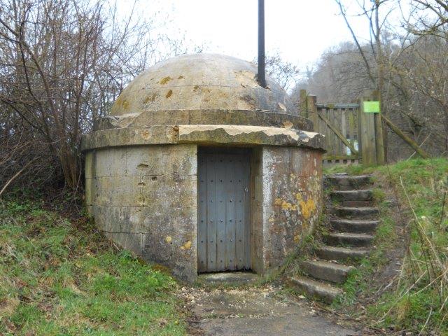
BATHEASTON
Photo by Colin Sinnott with expressed permission
I am particularly indebted to Colin for providing so many photographs of lock-ups in
the West Country and indeed elsewhere.
ooooooooooooooooooooooooooooooooooooooooooooooooooooooooooooooooooooo
In complete contrast, the former lock-up at Misterton in South Somerset is of completely different design and seems to be in use as a farm building.

MISTERTON
Photo courtesy of Maureen Albert with expressed permission
This lock-up, which is PRIVATE PROPERTY, is situated alongside the A356 approaching Misterton from South Perott, in a field next to the cemetery, just after the crossroads (A3066) at the Misterton village sign. The date is not known.
The following article by Maureen Albert, together with the above photograph, appeared in Misterton Village Magazine
in December 2012 :
" A typical outbuilding with an interesting history, this was at one time the Misterton Village Lock-up, providing space for local drunks to sober up, and perhaps restrain worse offenders. More recently its human habitation has been limited to the occasional tramp, but it has served as both hen house and pig pen. It can be found on the opposite side of a hedge to the cemetery, in the field, near the road (A356) at grid reference 481 079 (Ord Survey Sheet 193, Taunton and Lyme Regis)."
I am grateful to Maureen Albert for allowing me to copy her article and photograph.
PLEASE RESPECT PRIVATE PROPERTY
ooooooooooooooooooooooooooooooooooooooooooooooooooooooooooooooo
Fairly similar in design to Misterton, the lock-up at Freshford, near Bath, is situated in Church Hill, BA6 6BX just below the church. In many villages the lock-up was situated near to the church or the market place, and indeed often adjacent to a pub.
This lock-up dates to the late 18th century and was later used to house the village fire engine.
This lock-up dates to the late 18th century and was later used to house the village fire engine.

FRESHFORD
OS Grid Reference: ST7895160149
OS Grid Coordinates: 378951, 160149
Latitude/Longitude: 51.3400, -2.3036
Photo by Colin Sinnott with expressed permission.
It was Grade 11 listed 19.10.1983 (No.32281) and described as :
Lock-up, fire engine house, now store. Late C18th. Built into wall of Church Hill. Rubble;
lean-to tiled roof. Plank door with strap hinges and small cast iron grille window.
Parish records describe the building as a fire-engine house in 1815.
Listing NGR: ST7895160149
Often this type of lock-up was little used and eventually became store rooms and the like. In many cases these tiny buildings were used to house the burgeoning fire appliances, as it was in this case.
ooooooooooooooooooooooooooooooooooooooooooooooooooooooooooooooooooo
No comments:
Post a Comment