At the end of Kirkgate there is a crossroads. Burras Lane, the road to the right climbs up past the church, through modern housing and onto West Chevin Road which climbs steeply up the west end of the Chevin and over to
Menston and Guiseley.
Menston and Guiseley.
Burras Lane also connects to West Gate and the roads to Ilkley and Bradford.
At the same point, Station Road ahead slopes up towards The Chevin and ends at the point where the railway station once stood. A branch line to Otley was opened in 1865 and closed in 1963 following the Beeching report.
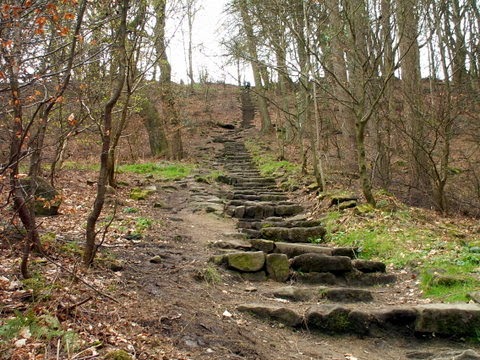
The line of the old railway forms the A660 bypass road which opened in 1984 and a footbridge crosses this road to give access to a footpath which climbs steeply to the top of The Chevin.


Spectacular views are to be seen from The Chevin over the town.


View from the by-pass towards the town


Back at the crossroads Bondgate leads to the Leeds road.
Immediately on the right, a sign on a tea shop declares that it was once the home of Thomas Chippindale.


Thomas Chippendale, the celebrated cabinet maker was indeed christened at Otley Parish Church on 5th June 1718. A sign on a building in Boroughgate at the Junction with Wesley Street, declares that Chippendale , the son of an Otley carpenter, was born in a cottage formerly on that site.
 There is also a fine statue of Chippendale outside the Old Grammar School in Manor Square.

Back at the crossroads Bondgate leads to the Leeds road.
Immediately on the right, a sign on a tea shop declares that it was once the home of Thomas Chippindale.
Thomas Chippendale, the celebrated cabinet maker was indeed christened at Otley Parish Church on 5th June 1718. A sign on a building in Boroughgate at the Junction with Wesley Street, declares that Chippendale , the son of an Otley carpenter, was born in a cottage formerly on that site.

On the left the old Woolpack Inn closed down in 2009 and is now an arts centre.
The old pub sign still remains.


The narrow street at the side of the Woolpack leads to Mercury Row and gives a good impression of the ambience of this area.


A little further on just past The Woolpack is Newmarket which leads back down to the Market Place. It is a narrow street with minimal traffic. With small shops and tea rooms it is a good place to meander.


These two cottages have date stones for 1761 and 1733


The Junction Inn, dating back to the mid 19th century, with its stone floor and open fire is one of the best known pubs in Otley.

The Rose & Crown in Bondgate was built in 1731 probably as a farmhouse - a haystack fire in the yard was reported in 1873. The first known licensee was in 1821. A 2ft long iron cross was discovered on an outside wall in the 1970's may be a Corn Cross. An unusual cricket bat hangs in the bar, made of one piece of wood of extra width and painted splice. There is a Rose & Crown painted on the blade together with several scratched names and may have been made for a charity cricket match but its age is not known. The pub which still has that rustic feel about it, and which has been extended into an adjoining cottage.

This old iron cross was discovered in an outside wall at the rear of the pub and is thought to be a Corn Cross.

On the opposite side of the road this old cobbled alleyway is now cut off
by Sainsbury's supermarket.
No comments:
Post a Comment