My next blogs will be my take of English counties starting with
Cornwall and Devon.
.JPG)
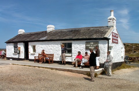
Lands End is of course the most westerly point in England, some 874 miles from John O' Groats in Scotland. This is an Area of Outstanding Natural Beauty.

Lots of first and last here, not least the phone box and the post box.
There is a mixture of retail outlets to tempt the many tourists.


The first and last house is now a tea room popular with tourists.

Although the sea on this rugged coast is very cold it is also very blue

The amazing Ancient Greek style Minack Open Air Theatre (1923) is built into the foot of the cliffs overlooking the lovely Porthcurno Bay to the south.

The Logan Rock Inn at Treen near Penzance has an interesting sign which recalls an event early in the 19th century involving a huge local rocking stone known as The Logan
In 1824 an army officer, Lt Goldsmith and some of his friends allegedly pushed the rock over the cliff, and such was the local outcry that the Lt. had to restore the rock to its original position on the cliff top at his own expense. It was no mean feat considering that the rock weighed some 80 tons! and apparently it cost £100, a huge sum of money in those days, to lift the rock back
onto its perch.
The rock is still there, now under the care of The National Trust.
The name derives from the Cornish word ‘log’ – to move.

A culinary delight in Cornwall
They still celebrate ‘Tom
Bawcock’s Eve’ every year on 23rd December at the Ship Inn in
Mousehole near Penzance.

Penzance is a harbour town overlooking Mount's Bay with views over to St Michael's Mount. Chapel Street is lined with some unusual buildings, none stranger than The Egyptian House dating to 1835. This building with its curious façade is now in the care of the National Trust.

Lower down Chapel Street
you will be surprised to see the figure of a smuggler on the roof of the Admiral
Benbow Inn. This fine model draws attention to a fine old
nautical inn with its very interesting unspoilt interior, taking us back to a
former time.

St Michael's Mount emerges dramatically from the sea in Mount Bay. When the Normans conquered England in 1066 they saw the resemblance of this little island to their own Mont-St-Michel at the other side of the English Channel and invited the Benedictine monks to build an abbey. The abbey became a fortress at the Dissolution as part of coastal defences but it was subsequently turned into a magnificent house. The Mount is connected to the mainland by a causeway which is covered at high tide and can be visited.


St Michael's Mount

Up on the Atlantic coast St Ives is the typical seaside resort around a fine harbour and its beaches are noted for surfing.
This is a favourite resort for artists.
This is a favourite resort for artists.


Fisherman's chapel

John Knill left his own epitaph and in some
style. He was born at Callington in
1733 and subsequently went to St Ives to work with a relative, a
solicitor. He lived in Fore Street in
what is now known as Knill’s House.
John Knill became very popular in St Ives and in 1762 he became
Collector of Customs, holding the post for 20 years. At the age of 34 he became Mayor of the town.
In 1782, Knill moved to London
Not content, Knill also made plans in his will for his quinquennial celebrations. Once every five years, a ceremony would take
place on 25th July (St James’ Day).
Beginning at The Guildhall in St Ives, a party of ten girls, all under
the age of ten years, dressed in white, and daughters of Cornish fishermen,
seamen and tinners, would walk up to Knill’s Steeple accompanied by two elderly
widows and a fiddler. There they were to
dance around the steeple for half an hour, singing the 23rd psalm,
while locals dignitaries would stand and watch. This ceremony takes place as laid down in
the will and has done so since 1801 when John Knill was actually present! He died on 29th March 1811 at Greys Inn Square London
In his will, Knill wrote :
In his will, Knill wrote :
‘ It is natural to love those of whom you
have had the opportunity of serving and confess I have real affection for St
Ives and its inhabitants in whose memory I have an ardent desire to continue a
little longer than the usual time those do of whom there is no sensible
memorial. To that end my vanity prompted
me to erect a mausoleum.’

Inside the church
of St Senora village of Zennor near St Ives


Back on the south coast, the tip of the Lizard Peninsular is the
most southerly part of England. This is also an Area of Outstanding Natural Beauty

A fig tree grows
out of the wall at the old church at Manaccan. The wall has a two outer facings of
stone with a space between filled with rubble, which has a enabled the tree to
grow. The origin of this 200 year old
tree is not known.

The town of Falmouth, a popular resort with its sheltered harbour, stands on
the south coast where seven rivers flow into a stretch of water known as
the Carrick Roads.


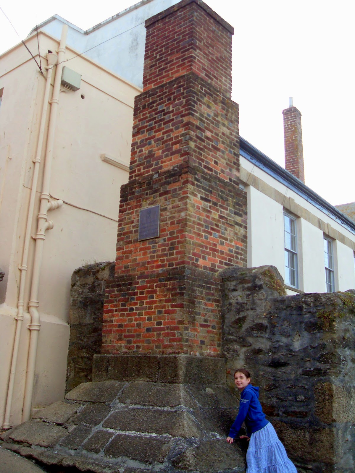
The King's Pipe on Customs Quay is a reminder of the 19th century.

The drowned river valley of the long stretch of water is so deep that
ocean going ships can use it.

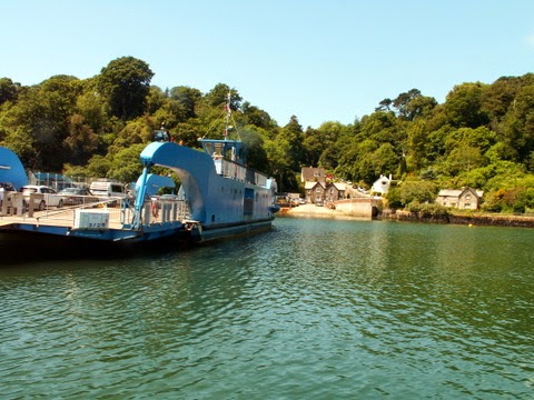
A ferry service between Falmouth and Truro gives tantalising view of the lovely inlets and countryside on both sides


The only crossing point between Falmouth and Truro is where the King Harry car ferry makes a 10 minute crossing from Feock to Philleigh, saving a 26 mile detour via Truro. This chain ferry, thought to be named after King Henry V1, was initiated in 1888 and carries up to 34 cars.

Truro is the administrative centre of Cornwall and although it has a population of only some 20,000, it is the only city in the county, designated aas such by Queen Victoria. The Cathedral was completed in 1910, the first new cathedral to be built since St Paul's. It is unique in being one of only two cathedrals in the country with three spires, the other being at Lichfield in Staffordshire.


The town prospered as a port on the Truro River in the 1800's


The gothic-revival Cathedral, built on the site of the old St Mary's church, took 30 years to build between 1880 and 1910


A plaque on the wall of a Georgian building reminds us that Truro was the first stop on The Trafalgar Way
The Trafalgar Way was inaugurated in 2005 when the Princess
Royal unveiled a plaque at Falmouth in Cornwall to launch a series of events
along the Way.
The Trafalgar Way is the historic route used to carry
dispatches, with news of the Battle of Trafalgar, overland from Falmouth to The
Admiralty in London.
In 1805, Lt. Lapenotiere of HMS Schooner, Pickle, reached
Falmouth on 4th November enduring bad weather. He then continued by
express post-chaise to London with 21 stops to change horses on the 37 hour 271
miles journey. At the Admiralty he delivered the news of the decisive defeat of
the combined French and Spanish fleet off Cape Trafalgar and the death in
action of Vice Admiral Lord Nelson. The news was immediately passed on to the
Prime Minister
and the King.
The victory removed the threat of an invasion of England by
the armies of Napoleon Boneparte

The strangely named hamlet of Come to Good is situated just south west of Truro. It consists of a farm, seven houses and a charming Quaker Meeting House dating to 1710.

The Quaker Meeting House
South east of Truro is the village of Veryan.
Five curious
circular houses can be seen in this tranquil village. These delightful 19th century
‘round houses’ are each topped with a conical thatched roof and a cross. They were built in the early 19th
century by the local vicar and landowner Jeremiah Trist for £50 each and their shape stems from ancient traditions that the
devil likes to enter a house by the north wall and to hide in corners.

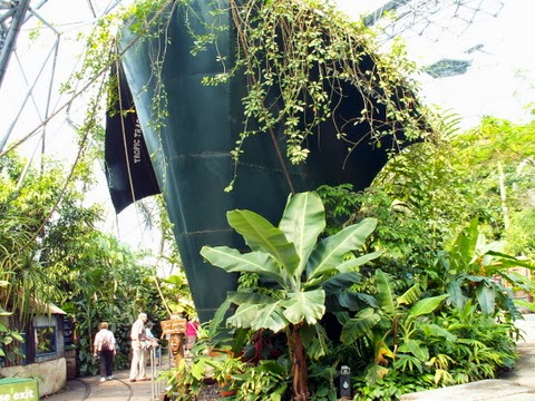
The Eden Project is an amazing global garden located in a reclaimed clay pit near St Austell. The complex is dominated by two huge adjoining domes that house thousands of plant species. The domes consist of hundreds of hexagonal and pentagonal inflated plastic cells supported by steel frames. The project took 2 1/2 years to construct and opened in 2001.


The Tropical Biome covers 3.9 acres. It is 180 feet high, 328 feet wide and 656 feet long and is kept at a tropical temperature and moisture level.


These
totems, created by West African sculptor El Ahatsux, came from charred timbers
recycled from a part of Falmouth Docks which was destroyed by fire. They
started their life as trees in West Africa.

The Mediterranean Biome covers 1.6 acres and measures 115 high, 213 feet wide and 443 feet long. It houses warm temperate and arid plants and various sculptures.


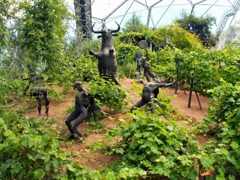
The Rites of Dionysus
Sculptures in the Mediterranean Dome by Tim Shaw depict
the Greek God of the vines.
Tim relates that ' Dionysus is a creature of mystery and the personification of nature itself in its wild untamed state. His identity takes on many forms, virile youth, lion, serpent and, as shown here, a bull.'
Dionysus was associated with horticulture, fertility, wine, festivities, intoxication and also destruction. He started out with good intentions as the God of vegetation but things changed when he went from growing the vine to drinking its fermented juices big time. In this sculpture he stands straddled between ancient landscapes and the irrigated lands of intense agriculture.
The outdoor area represents the temperate regions of the world.


There is also a huge open air concert stage.

The Core is the latest addition to the site which provides exhibition and educational facilities and was opened by The Queen in 2006.

One of the exhibits is The Seed by Peter Randall-Page. Standing four metres high it is a huge egg shaped stone covered in a complex pattern based upon the geometric and mathematical principles that underlie plant growth, which took 4 years to make. It was gently lowered into position through a skylight into a bell shaped chamber in the new building.
One of the biggest sculptures in history it started as a
167-tonne boulder of Cornish granite probably 300 million years old.

A very unusual tree – Liriodendron Tulipfera or Tulip Tree – stands proudly at the
bottom of Tanhouse Road
It flowers in June.

Newquay on the Atlantic coast is Cornwall's premier seaside resort with no less than ten beaches. many of them firm favourites with of surfers.


The Huer’s Hut is a small
white Grade 11 listed building on a headland above the harbour at Newquay.
A plaque near the building
tells us :
‘This building thought to
date from the 14th c. was used as a
look-out by a Huer at the
time of year when shoals of pilchards
were expected in the bay. A
call on his horn raised the hue and
cry and alerted the
townsfolk to the arrival of the fish. By means
of hand signals the Huer
enabled the fishermen to position their
boats and encircle the
shoal with their nets.
Prior to its use by the
Huer this hut may have been a
Hermitage. The hermit
possibly being the person entrusted with
The lighting of the beacon
fire for the guidance of shipping.
Externally this building
has a large typically Cornish late
medieval chimney and a
narrow stairway leading to the roof.
There are two windows with
drip moulds one of which (now
blocked) has a mullion
visible from the inside. Here too, can be seen
an early fireplace altered
in the 19th c. possibly during the
Restoration of 1836.


Fistral beach on the west side of Towan Head west of Newquay
is a must for the surfers.
 |
  The lovely beaches continue round to Pentire (meaning promontory)  and the estuary of the tidal River Gannel amidst stunning scenery and fantastic displays of wild flora.    Padstow, north of Newquay, is an old fashioned harbour town overlooking the Camel Estuary. A curious May Day custom to welcome the summer is maintained when the 'Hobby Horse' is brought out to lead the festivities, as it has done for many centuries and believed to have Celtic origins.  
Peeping out of the sand dunes overlooking Daymar Bay on
the eastern tip of the Camel Estuary, is the tiny church of
St Enodoc which was once completely buried in the sand. The ancient village nearby was also engulfed
in sand and abandoned. In 1864 the
church was cleared of sand and restored.
Former poet laureate, Sir John Betjeman is buried in the
churchyard.
  Former poet laureate, Sir John Betjeman is buried in the churchyard. .jpg) Further inland, Bodmin is a small town which was formerly the county town until the Crown Courts moved to Truro  Bodmin Jail was built in 1779 by prisoners of war and was operational until 1927. More than fifty people were hanged there. the last in 1909. During WW1 Britain's treasures , including the Crown Jewels, were stored there. Now mostly ruined it was bought in 2004 by a family who are trying to restore it. At present they are offering a restaurant, part visits and ghosts tours.   Prior to the building of Bodmin Jail, debtors were held in a small prison in Crockwell Street in the centre of Bodmin. An unusual pub is situated in the old courtyard and is full of memorabilia including a stuffed lion. Families of the inmates would pass food through a hole in the wall which gives the pub its name. The Hole in the Wall. Imprisonment for debt was abolished in 1869  The huge slate quarry at Delabole to the north of Bodmin has been in operation for over 200 years. 
An old sign post can be seen at
the cross roads of the A3072 and the B3254
near to Stratton.
Strangely it is painted red and is known
locally as
The Red Post, It was once the site of the gallows.
 Morwenstow is a small village on the extreme north west coast and is best known for its eccentric vicar, the Rev. Stephen Hawker who lived there for 40 years. He built the rectory there in 1838 and its curious chimneys were designed to represent Hawker's previous churches.  |
No comments:
Post a Comment