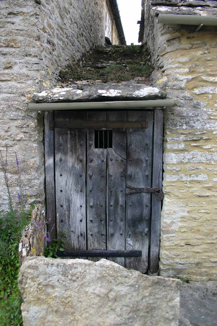
The diminutive lock-up at Filkins is squeezed between two buildings in Rouses Lane, GL7 3JF
and dates to the 18th century.
 |
FILKINS OS Grid Reference: SP2382304233 OS Grid Coordinates: 423823, 204233 Latitude/Longitude: 51.7363, -1.6564 Photo by Ann Williams with expressed permission.
I am grateful to Ann Williams for sending me this photograph.
It was Grade 11 listed 4..5.1989 (No.253516) and described as : Former pair of cottages, the right at one time used as outbuilding, both now serving as museum. Village lock-up is attached to left end, and to front are remains of stone slab fences. Left cottage is early C18 in origin, altered C20; remainder is early-mid C19. Coursed limestone rubble. Left cottage, formerly thatched, now has mid C20 stone slate roof, and large rubble stone chimney to right with stone slated off-sets. Formerly one storey and attic; 2 bays. Ground floor openings, with ammonites set into the walling. Roof has 2 C20 skylights. Right cottage has Welsh slate roof and is taller, formerly of one storey and attic but with floor removed C20. 2 bays, the right blind, the left with later lean-to, formerly a tall entry but now blocked with rubble walling and 2-light casement. Central board door with C20 wooden lintel. 2-light barred wooden casements with older wooden lintels in right gable end. Lean-to extensions to rear, dated 1975, are not of special architectural interest, Lock-up is set in narrow space between walls of left cottage and The Old Post Office. Space is covered by roof of large stone slabs, and has old board door to front with studs, strap hinges and small square grille. Stone bench inside at far end. Included for group value, (Illustrated in Country Life: April 28th 1944, p731) Listing NGR: SP2382304233 Source: English Heritage Listed building text is © Crown Copyright. Reproduced under licence: PSI Click-use licence number C2008002006. ooooooooooooooooooooooooooooooooooooooooooooooooooooo The lock-up at Stonesfield is situated near to the entrance to the village church, High Street, OX6 8PT and dates to the late 17th or early 18th century. STONESFIELD OS Grid Reference: SP3936417110 OS Grid Coordinates: 439364, 217110 Latitude/Longitude: 51.8512, -1.4299 Photo by Ann Williams with expressed permission
I am again grateful to Ann Williams for sending me this photograph.
It was Grade 11 listed 15.5.1988 (No.252565) and described as :
Lock up. Probably late C17 or early C18. Squared and coursed limestone with stone slate roof. One storey. Gable to front. Doorway with flat stone arch and nail-studded boarded door with wrought-iron strap hinges, internal sliding bolt, and iron-barred grille. Interior: patterned stone floor and circular domed ceiling constructed from corbelled stone slates. Bench along rear wall with iron ring for shackles. (VCH: Oxfordshire: Vol XI, pl84) Listing NGR: SP3936417110 Source: English Heritage Listed building text is © Crown Copyright. Reproduced under licence. Andrew Plumridge 5 days ago (August 2014)
Although the precise date of the lock-up is unknown, most experts and local authors accept George Osborne’s diary account indicating that it was erected in 1830 as a substitute for the old stocks. If that is true, the lock-up was probably built in response to the Agricultural Riots that took place across the country that year and frightened many local officials and authorities. Even so, most lock-ups were built on the instruction of the Justices at the Court of Quarter Sessions, but no such records appear to exist in this case. Given that there is also no mention of the lock-up being used, it has allowed some to assume that the lock-up was built out of civic duty rather than any local need but I consider this unlikely. Most parish authorities resented the need to spend money on local prisons and only built lock-ups when ordered to do so.
The building stands on part of the Yard of the former Rose and Crown PH, close to the site of the village pound. The last pinder and village constable was the former slate-digger John Croxford, who handed his key and handcuffs to the churchwardens when he retired from office. They in turn gave the key to the rector who used the lock-up as a coal store for his church boiler. In 1965 it was cleared and cleaned to make it presentable, at which time the door was carefully repaired. oooooooooooooooooooooooooooooooooooooooooooooooooooo The unusual cone-shaped lock-up at Wheatley is situated in Church Road, OX33 1NB and dates to 1834. WHEATLEY OS Grid Reference: SP5950605840 OS Grid Coordinates: 459506, 205840 Latitude/Longitude: 51.7481, -1.1394 Photo's by Roy Pledger. It was Grade 11 listed 21.5.1985 (No.246958) and described as :
Lock-up. 1834. By Cooper, mason. Squared coursed limestone rubble. Hexagonal
Listing NGR: SP5950605840pyramid plan. Heavy plank door with stone lintel. Apex cap and ball finial. Noted as containing stocks. Interior not inspected. (V.C.H.: Oxfordshire, Vol.V, p. 109; Buildings of England: Oxfordshire, p.838) .
Source: English Heritage
Listed building text is © Crown Copyright. Reproduced under licence.
The sturdy door appears to be original.
oooooooooooooooooooooooooooooooooooooooooooooooooo
|


No comments:
Post a Comment